Large parts of the United Kingdom are waking up to continued snowfall and treacherous conditions today, Thursday, 20 November 2025, following a night of significant wintry weather. The Met Office has a series of severe weather warnings active across the nation, with the potential for substantial travel disruption, school closures, and dangerously low temperatures.
Where is the snow falling right now?
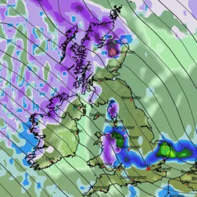
A live radar map from Ventusky provides a real-time view of exactly where snow is currently settling across the country. The most severe conditions are concentrated in the North East of England and Yorkshire, where an amber weather warning is in force. Forecasters predict up to 25cm of snow could accumulate in these regions, with the Met Office warning that rural communities risk being cut off by the intense flurries, which may create occasional blizzard conditions.
However, the disruptive weather is far more widespread. Separate yellow warnings for snow and ice blanket Scotland, Northern Ireland, Wales, the south-west, and eastern England, indicating a national-scale weather event. These alerts are set to remain until 11.59pm on Thursday.
Travel chaos and widespread disruption
The wintry blast has already caused significant travel chaos. On Wednesday night, motorists in the North East and Yorkshire faced severe difficulties, with numerous vehicles becoming stuck in the snow. This disruption continued into Thursday morning, with the A90 in Aberdeen closed in both directions between the Cleanhill and Stonehaven roundabouts due to snow, with police advising drivers to completely avoid the area.
National Rail has urged all rail commuters to check their journeys before travelling, warning that speed restrictions may be necessary for safety. This is likely to lead to widespread cancellations, alterations, and delays to services across the network. The AA has issued urgent advice to drivers. Shaun Jones, an AA Expert Patrol, emphasised the dangers, stating: "Stopping distances can increase tenfold on icy surfaces, so slowing down and leaving plenty of space is absolutely vital. Drivers should plan ahead, stick to main routes and allow extra time for their journey."
Beyond the roads, the snowfall has forced the closure of many schools in the Highlands and Aberdeenshire, disrupting education for thousands of children.
Freezing temperatures and the forecast ahead
The driving force behind this extreme weather is a grip of cold Arctic air over the UK. Overnight, the mercury plunged to a frigid -6°C in Spadeadam, Cumbria. However, the Met Office has warned that the coldest temperatures are still to come, with the potential for an astonishing -12°C in parts of Scotland on Friday, particularly in areas with lying snow.
While a change is on the horizon for the weekend, with temperatures expected to rise closer to the seasonal average as wetter and windier weather moves in, the forecaster notes it will not be as "exceptionally mild" as the conditions experienced earlier in November. For now, the country is firmly in the grip of an early winter freeze, with the public advised to stay informed and exercise caution.


