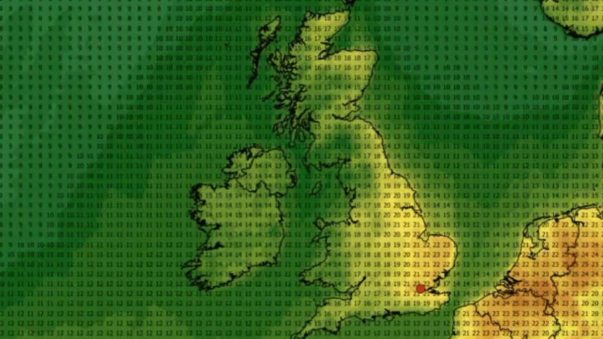
Fresh weather maps indicate that the balmy conditions enjoyed across much of the UK in recent days will continue into early next month. Data from WXCharts shows orange and yellow shading over several regions on May 1, signalling a warm climate. Highs of up to 23C are anticipated around 6pm that day across many parts of the country.
Hottest Regions
The hottest conditions are predicted for London and parts of the East of England, including near Norwich and along the North Norfolk Coast, where the mercury is expected to peak at 23C. Areas close to Norwich and North Norfolk are likewise set to experience these pleasant temperatures.
Readings of 21C to 22C are forecast across Kent, including Southend-on-Sea, as well as in cities such as Cambridge, Colchester, Ipswich and Margate. The warm spell is expected to get going earlier in the day, with 22C predicted in London and 21C across Kent, Norfolk and Suffolk.
Met Office Forecast
The Met Office's long-range forecast covering Thursday, April 30 to Saturday, May 9 states: "High pressure is likely to lie close to the UK at the start of this period. Most places will be dry with sunny spells and light winds, although there could be some overnight mist and fog."
"Into the first week of May, conditions will probably become more changeable with low pressure systems becoming more likely. This means an increasing chance of showers or longer spells of rain, with a risk of strong winds at times. Temperatures are likely to be close to or slightly above normal."
This follows as mild conditions persist across substantial portions of the UK, with the Met Office noting that the country was poised for pleasant and bright weather over the coming days. The forecaster said: "Fine and sunny weather will dominate for many over the next couple of days as warm air is drawn northwards across the UK. Highs in the low to mid-20s are expected widely across England and Wales today, with the warmest conditions often found in sheltered areas, including parts of northwest Wales, where 24C or even 25C is possible."
Further Outlook
A further long-range forecast between Saturday, May 9 and Saturday, May 23 reads: "Low pressure systems will probably dominate across the UK at the start of this period. This means showers or longer spells of rain are likely at times, heavy in places with a risk of strong winds. Temperatures will probably be close to or slightly below normal. Later in the month more settled, drier conditions may begin to develop with temperatures perhaps rising slightly above normal."
The UK has already witnessed exceptionally mild conditions this spring. A peak of 26.6C was logged at Kew Gardens in south-west London on April 8, which the Met Office verified was the hottest day of 2026 so far. The highest April temperature on record remains 29.4C recorded in London at Camden Square in 1949.
Met Office deputy chief forecaster Steven Keate had earlier said that high pressure would "remain broadly in charge" throughout the weekend and "most places will remain dry with a fair amount of sunshine". He went on: "As is often the case, there are a few exceptions, with cloudier conditions for some at times and patchy rain possible for northern Scotland later in the weekend. But in the sunshine, we’re expecting temperatures to steadily climb, likely peaking in the low 20s on Friday and over the weekend. Onshore breezes will keep some coastal areas somewhat cooler."


