
UK Snow Maps Predict Another Severe Blizzard with Four-Inch-Per-Hour Snowfall Next Week
Following a weekend of widespread wintry weather chaos across the United Kingdom, forecasting models are now indicating that a second major blizzard could strike the country next week. This new storm threatens to bring intense snowfall, with rates potentially reaching up to four inches per hour in some areas, burying cities including London and Birmingham under a fresh blanket of snow.
Timeline and Impact of the Impending Snowstorm
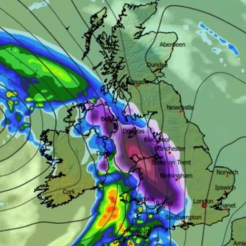
According to the ECMWF weather model, the blizzard is set to commence around midnight on Tuesday, initially targeting Northern Ireland, Wales, and western regions of England with heavy snow and rain. By Wednesday morning at approximately 3am, the snow is expected to spread rapidly across the nation, engulfing most of central and northern England, while Scotland may also experience significant snowfall at this time.
Major urban centres such as London, Birmingham, Manchester, Liverpool, Cardiff, and Glasgow are all projected to be in the firing line during the early hours of Wednesday. By 6am, the heaviest snowfall is forecast to concentrate in the East Midlands and East Anglia, before subsiding shortly after, potentially leaving millions of residents waking up to a winter wonderland.

Snowfall Intensity and Accumulation Predictions
The data suggests that where the snowfall is most intense, it could fall at a staggering rate of around four inches per hour. Snow coverage charts indicate that almost every part of the UK, excluding the southernmost regions of England, will have snow settled on the ground by 6am on Wednesday.
Snow depth charts further predict substantial accumulations in various regions:
- Low-lying areas of Scotland could see up to 7cm (2.8 inches) of snow.
- The North Pennines may experience accumulations of 9cm (3.5 inches).
- Wales could receive as much as 8cm (3.1 inches).
- The Midlands might see around 6cm (2.3 inches).
Met Office Warnings and Broader Weather Implications
The Met Office has already issued numerous weather warnings for snow and ice, covering almost every inch of the UK this weekend. However, the forecast for next week also includes risks beyond snow. BBC Weather warns that flooding is a concern in several areas, as heavy rain is expected alongside the snowfall.
The broader weather pattern suggests that the widespread cold will be temporary, with high pressure to the north likely weakening or being replaced by weak low pressure near Iceland by the end of the week. This shift could allow south-westerly wind flows to develop, bringing milder air across the UK, though Scotland may remain chillier with temperatures close to or slightly below seasonal averages.
This more Atlantic-influenced regime is predicted to bring periods of wet and windy weather, with frontal systems crossing the UK and above-average rainfall amounts expected. This raises further risks of local flooding, particularly in parts of southern and south-western UK, and in South Wales. Snow may still occur on the colder leading edge of these rain bands, especially over higher ground in northern areas.
There is also a signal for high pressure to build over the eastern Atlantic between weather systems, delivering brighter but chillier interludes with some wintry showers on north to north-westerly winds. As the nation recovers from this weekend's disruptions, residents are advised to stay updated on forecasts and prepare for potentially hazardous travel conditions and further weather-related challenges in the coming days.


