
Advanced weather forecasting maps have revealed that the United Kingdom is bracing for a severe double onslaught of snow, with twin blizzards predicted to bury major cities under several inches of accumulation in the coming days. The meteorological data indicates that these storms could bring snowfall rates of up to four inches per hour in the most affected regions, posing significant disruption to travel and daily life.
First Blizzard to Strike This Weekend
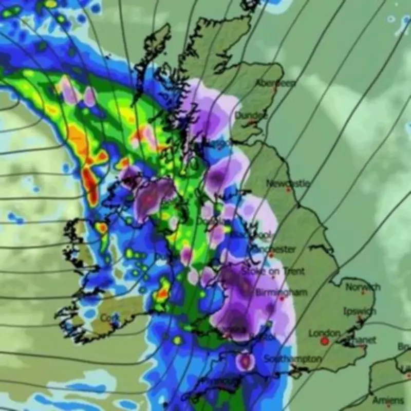
The initial blizzard is forecasted to commence in the early hours of Sunday morning, targeting Northern Ireland, Wales, and western parts of England and Scotland. As the day progresses, the snow is expected to advance eastward, enveloping key urban centres by 6am. According to the ECMWF weather model, cities such as London, Birmingham, Manchester, Newcastle, and all of Yorkshire will experience snowfall, alongside extensive areas of Scotland and parts of East Anglia.
Snow coverage charts project that by 9am on Sunday, only the south-west, select parts of Wales, and certain regions of Northern Ireland will remain free of settled snow. The Scottish mountains are anticipated to bear the brunt, with accumulations potentially reaching 160 centimetres (63 inches). Other areas forecasted include southern Scotland with 13 centimetres (five inches), northern England with 14 centimetres (six inches), Wales with 8 centimetres (three inches), and the Midlands with 4 centimetres (1.5 inches).

Second Blizzard Follows Early Next Week
A second, equally intense blizzard is slated to sweep across the UK next Tuesday, initiating around 6pm with heavy flurries in Northern Ireland and Wales. Similar to the first storm, snowfall rates could again hit four inches per hour in localised areas. This system will then migrate over central and northern parts of the UK throughout the day, impacting numerous cities in both England and Scotland.
By midnight on Tuesday, the most severe snowfall is predicted to concentrate over Yorkshire. Subsequent snow coverage maps for February 18 indicate that the North Pennines could see up to 48 centimetres (19 inches) of settled snow, while Northern Ireland might accumulate as much as 26 centimetres (10 inches).
Met Office Issues Warnings and Long-Range Forecast
The Met Office has already issued warnings for snow and ice, covering northern England and Scotland for Thursday and Friday of this week, with up to four inches of snow expected to settle in some locations. Looking further ahead, their forecast for February 16 to 25 suggests that Atlantic low-pressure systems will dominate, bringing showers or prolonged spells of rain, with some snow likely in northern areas, primarily on higher ground.
Strong winds are also possible, especially along coastal regions, with temperatures hovering around seasonal norms. Later in this period, there is a chance for drier and more settled conditions to develop.
For the extended period from February 26 to March 12, the Met Office notes low confidence in the prevailing weather patterns but signals potential for both unsettled conditions with heavy rain and periods of drier, more settled weather that could lead to colder temperatures. The latter scenario is considered slightly more probable, particularly early in this timeframe.
This dual blizzard event underscores the volatile winter weather patterns affecting the UK, with residents advised to stay updated on official forecasts and prepare for potential travel disruptions and hazardous conditions.


