
Valentine's Day Blizzard Set to Bury UK Cities Under Heavy Snow
Advanced weather forecasting maps indicate a severe blizzard could sweep across the United Kingdom this weekend, commencing on Valentine's Day and continuing into Sunday. The storm is projected to deliver substantial snowfall to numerous regions, with some areas potentially receiving up to 63 inches of accumulation.
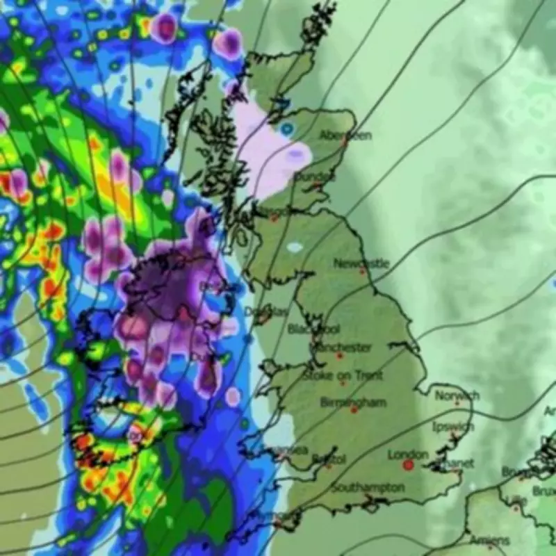
Timeline and Geographic Spread of the Snowstorm
According to the latest GFS weather model data, the snowfall will initiate over Northern Ireland and parts of northern Scotland during the evening of Saturday, February 14th. Ireland is also expected to experience heavy snow around 9pm on that day.
The meteorological maps suggest the snow will then propagate eastwards, eventually covering nearly every part of England, Wales, and Scotland. By approximately 3am on Sunday, precipitation is forecast to extend from the southern coast of England all the way to the far northern reaches of Scotland.

Major Urban Centres in the Firing Line
Several key cities appear directly in the path of this winter weather system. Birmingham, Manchester, Liverpool, Newcastle, Edinburgh, and Glasgow are all anticipated to receive significant snowfall. In areas where the flurries are most intense, particularly over elevated terrain, snow could fall at rates approaching four inches per hour.
By around 6am on Sunday, the snow is expected to reach London as it continues its eastward drift, also affecting East Anglia and sections of Yorkshire. The modelling indicates that most of the country will experience snowfall at some point during the weekend.
Projected Snow Accumulations Across the UK
Snow depth charts reveal stark regional variations in expected accumulations. Hills in northern Scotland could see up to 162 centimetres (63 inches) of settled snow by Sunday morning. Southern Scotland may receive around 12 centimetres (five inches), while hills in northern England could accumulate approximately 8 centimetres (three inches).
The Midlands and regions further south are likely to see more modest accumulations of 1 to 2 centimetres. These projections highlight the significant impact the storm could have, particularly in northern and elevated areas.
Official Weather Agency Forecasts and Warnings
The Met Office has corroborated these predictions, indicating colder conditions developing on Friday with a chance of snow showers, especially in northern regions. Their extended forecast for February 15th to 24th suggests Atlantic low-pressure systems will dominate, bringing showers or longer spells of rain.
The national weather agency states: "Some heavy rain is likely in places, probably focussed on western hills, with some snow at times in the north, mainly on high ground. Strong winds are possible at times, especially around coasts. Temperatures will probably be near normal. Later in the period, there is a chance that drier, more settled conditions may begin to develop."
Additional Meteorological Perspectives
BBC Weather forecasts also suggest further wintry precipitation this week, with snow expected over hills on Wednesday, Thursday, and Sunday. Their forecast explains: "Wednesday and Thursday will stay unsettled, with bands of rain or showers. Higher elevations in Scotland will have snow showers, and as colder air starts to come southwards, some snow or sleet should develop over the hills and mountains of Northern Ireland, Wales and northern England by late Thursday."
The BBC adds: "As a front clears southwards there could even be some wintriness over the hills of the Midlands and southern England temporarily, while sleet and snow showers blow across windward coasts elsewhere. Most areas should become drier and clearer by Saturday, with sharp frosts in places. However, a new frontal system from the Atlantic should start to bring milder air and rain on Sunday, although preceded by sleet and snow over higher ground, mainly in the northern half of the UK."
This confluence of forecasting models and official agency predictions underscores the potential for a significant Valentine's Day snowstorm across the United Kingdom, with particular severity in northern and high-altitude regions. Residents are advised to monitor updates and prepare for potentially hazardous travel conditions.


