Met Office Issues Winter Weather Readiness Alert
The Met Office has issued a stark warning to UK households, urging them to prepare an emergency kit containing seven essential items as the country braces for potentially severe winter weather in the run-up to Christmas.
In a social media post, the national weather service emphasised the importance of being #WeatherReady this winter, sharing guidance from its partners about preparing homes and gardens for harsh conditions.
The Essential Seven Items for Your Emergency Kit
Households are strongly advised to gather the following crucial supplies: water, snacks, necessary medication, warm clothing, baby formula and nappies (if applicable), and pet food (for pet owners).
This proactive advice comes alongside detailed meteorological analysis suggesting increasingly unsettled conditions across the nation.
Detailed Weather Outlook: Unsettled Conditions and Potential Snow
Looking ahead in its 10-day outlook, the Met Office's analysis indicates that high pressure across Scandinavia will dominate initially. However, as next week progresses, higher pressure to the north of the UK becomes more likely.
This atmospheric setup does not guarantee dry weather. Recent computer models suggest that a low-pressure system to the southwest could become more dominant, pushing further rain into southern and western areas.
The key meteorological uncertainty revolves around whether this low will push further north or if higher pressure will build from the north. This could shift weather patterns from an east-west split to a more pronounced north-south divide.
Despite the uncertainty, the forecast points to a continuation of generally mild conditions, with temperatures expected to remain above the seasonal average. However, the weather is set to become increasingly unsettled, with the wettest conditions anticipated in southern and western parts of the UK, particularly during the second half of next week.
Specific Snow and Rain Forecasts for Mid-November
Adding to the concerns, detailed weather model maps indicate that parts of Britain could experience significant wintry conditions. Between November 13 and November 17, some regions may face heavy rain and icy weather.
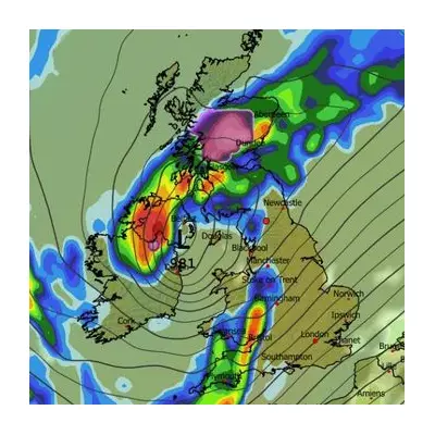
On November 13 at 6pm, heavy rain is forecast for Scotland, Northern Ireland, and parts of northern England, especially around Newcastle. More alarmingly, the Scottish Highlands - particularly around Inverness and Aberdeen - could see snowfall reaching up to 5cm per hour. Edinburgh may experience a mix of sleet or wet snow.
By November 14 at 6am, a few centimetres of snow are forecast across parts of the Highlands, while other parts of Scotland, including Aberdeen and Edinburgh, are set for rain. Wet weather is also expected in Newcastle, Belfast, Birmingham, Cardiff, and Plymouth.
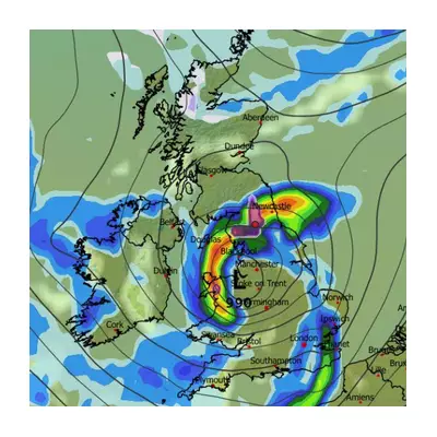
The situation is forecast to intensify on November 15 at 6am, with maps showing heavy rain and strong winds battering much of the country. Downpours will sweep through Northern Ireland and northern England, while the Highlands are set for wintry conditions, with snow likely over higher ground.
The Met Office attributes these unpredictable patterns to a weak and wavy jet stream, which is creating slow-moving weather systems and contributing to the high level of forecast uncertainty, particularly regarding the extent and timing of rainfall.