
A historic and catastrophic blizzard is poised to unleash chaos along the entire East Coast of the United States, with millions of Americans bracing for a storm that forecasters warn will rewrite the rule book on winter weather events. The National Weather Service has issued dire warnings, predicting that this potent Nor'easter will bring blizzard conditions and render travel impossible across a vast swath from Baltimore to Boston.
Unprecedented Storm Impacts and Warnings
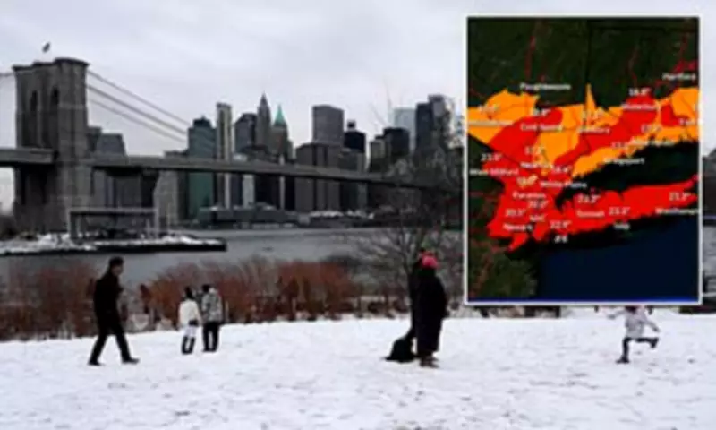
Nearly 54 million residents lie directly in the path of this monstrous storm, which is expected to dump staggering accumulations of up to two feet, or 26 inches, of snow. Accompanying the heavy snowfall will be ferocious wind gusts reaching speeds of up to 70 miles per hour. The storm system is forecast to begin as rainfall in some areas on Sunday morning before rapidly intensifying into a full-blown blizzard with heavy snow and strong winds, creating dangerous whiteout conditions overnight and persisting into Monday.
Meteorologists are emphasizing the extreme rarity of this weather event, suggesting it will be discussed for decades due to its intense and widespread impact. The blizzard is set to transform into a bomb cyclone, a phenomenon characterized by rapid intensification that could lead to historic consequences. The National Weather Service stated bluntly that blizzard conditions will quickly develop from the Eastern Shore of Maryland through southeastern New England, making travel extremely treacherous and potentially life-threatening in these regions.

Major Travel Disruption and Emergency Declarations
The storm has already caused massive travel chaos, with over 7,000 flights disrupted, including 6,578 cancellations and nearly 900 delays reported through Tuesday. New York City's airports are among the most severely impacted. This blizzard marks the first for New York City in nearly a decade, with a Blizzard Warning in effect from 1 p.m. Sunday through 6 p.m. Monday.
In response to the impending crisis, New York Governor Kathy Hochul has declared a state of emergency for New York City, Long Island, and portions of the Hudson Valley. New York City Mayor Zohran Mamdani urged residents to stay off the roads unless absolutely necessary, advising, "If you can stay home, stay home." The city is mobilizing a massive response effort, deploying 2,200 snow plows, hundreds of shovelers, and additional employees to combat the expected snow accumulation.
Similarly, New Jersey Governor Mikie Sherrill declared a state of emergency starting at noon Sunday, ahead of what she termed a 'severe' storm. In a historic first, all 21 counties in New Jersey are simultaneously under a blizzard warning, according to meteorologist Matthew Cappucci from MyRadar Weather.
Expert Forecasts and Dire Predictions
Storm chaser Nicholas Isabella captured the severity on social media, writing, "This isn't your average 'couple inches and slush by noon' event. This has the makings of the storms we study for years. The kind that rewrite seasonal totals, shut the city down, and get talked about decades later."
Forecasters warn that the combination of strong winds and the heavy, wet snow could down tree limbs and power lines, leading to sporadic or even extensive power outages. AccuWeather Meteorologist Alex Duffus noted, "The clinging nature of the snow and high winds will put a strain on trees and power lines, with extensive power outages anticipated."
Some of the heaviest snowfall is projected to occur overnight Sunday, with rates reaching as much as two inches per hour in certain areas, before gradually tapering off by Monday afternoon. Meteorologist Brady Harris highlighted the storm's rapid intensification, describing it as 'almost unheard of.' He explained that at peak intensity, the storm may even resemble a hurricane on satellite imagery, with a tight core and a powerful wind field wrapping around it, which is precisely why the impacts could become so extreme.


