UK Snow Maps Predict 'Beast from the East' Storm to Bury Cities Under 6 Inches
New weather forecasting maps indicate that a significant 'Beast from the East' storm could unleash heavy snowfall across the United Kingdom in early March, with up to six inches of snow potentially burying major urban centres. This development follows a period of relatively improved conditions after weeks of persistent rain and cold weather, suggesting a dramatic shift is on the horizon.
Storm Timeline and Geographic Impact
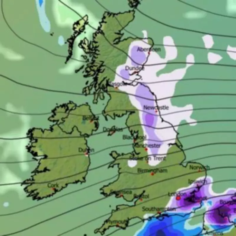
According to the GFS weather model, snow is expected to form to the east of the UK over the North Sea and continental Europe on March 7, before advancing westward across the country. Initial impacts are projected for midday on March 7, primarily affecting south-east England, including London, as well as the Pennines, north-east regions, and parts of Scotland.
Throughout the day, the snowfall is anticipated to spread extensively. By 9pm on March 7, maps show southern, central, and northern England almost entirely engulfed, with flurries beginning to reach Wales around this time. The situation intensifies by 9am on March 8, with heavy snow forecast across England and Wales, placing major cities such as London, Birmingham, and Manchester directly in the storm's path.
Snow Depth Projections and Meteorological Context
Snow depth maps reveal the potential severity of this blizzard, with approximately 14cm (roughly six inches) possibly settling across the Pennines in northern England. Similar accumulations of 14cm are predicted for North Wales, while the Midlands could see 7cm and northern Scotland around 9cm.
The Met Office has also noted the possibility of additional snow towards the end of February and the start of March. In its forecast for February 25 to March 6, the agency describes changeable conditions with Atlantic frontal systems moving across the country, interspersed with dry and bright intervals. It highlights that rain and showers will be heaviest in the west, with eastern areas receiving less precipitation, and temperatures fluctuating between milder and colder spells, potentially cold enough for sleet or snow showers in the northwest, especially over high ground.
Conflicting Forecasts and Long-Term Outlook
In contrast, BBC Weather suggests snow is unlikely but possible during this period. Its forecast for March 2 to 15 indicates low confidence, with signs of high pressure building near the UK, potentially leading to drier conditions and precipitation near or below average. However, the position of this high pressure could influence wind and precipitation patterns, possibly bringing frost and fog risks. Daytime temperatures are expected to be near or above seasonal averages, though chillier conditions may affect Scotland. There is a small chance of high pressure developing at higher latitudes, which could introduce a colder week with increased likelihood of wintry showers, though significant cold anomalies are not anticipated.
This impending storm underscores the unpredictable nature of UK weather as winter transitions into spring, with authorities and residents advised to monitor updates closely for potential disruptions.


