


Entertainment

Sebastian Stan Confirms Two-Face Role in The Batman: Part Two
Sebastian Stan reveals at Cannes he will play Harvey Dent/Two-Face in Matt Reeves' The Batman: Part II, filming in London this summer. Release set for October 2027.


Politics

A-List Assistants Reveal the Harsh Realities of Working for the Rich and Famous
A luxury employment agency reveals the brutal realities of working for A-list celebrities, including demanding requests and high turnover.


Sports

Pep Guardiola to Offer Advice to His Successor at Manchester City
Pep Guardiola ends his decade-long Manchester City reign with 20 trophies, including six Premier League titles. He pledges to contact his successor with advice: 'Be yourself.'


Crime

Mum-of-three 'lured to death by man who offered her job more than 100 miles away'
Angel Whitaker, 37, moved 100 miles for a job offered by ex-colleague Donald Pennington, 59, who she was romantically involved with. She vanished in April; Pennington charged with murder.


Health


Environment
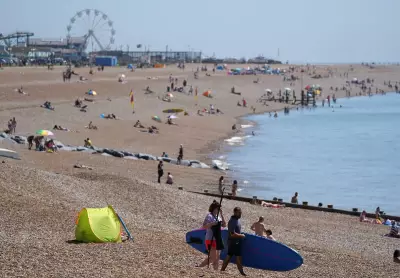
Man Dies on UK Beach Amid Record Heatwave
A man died after a medical incident on Hastings beach during a record-breaking heatwave. Sunday was the hottest day of the year, with amber health alerts issued.
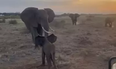
Lost Elephant Calf Reunited with Herd in Kenya Rescue
A four-month-old elephant calf, separated from her herd, was rescued by scientists in Kenya and joyfully reunited with her family, including her aunts Adelaide and Markle.

Tiny Blue Octopus Near Galapagos Is New Species
A palm-sized blue octopus found at 5,800ft deep near the Galapagos Islands has been identified as a new species, Microeledone galapagensis, using CT scans.

Gardeners Urged to Save Plants from Heatwave Now
UK gardeners can protect hanging baskets from heatwave damage with expert watering and positioning tips, including moving containers to shade.

Pope Leo XIV's AI Manifesto Warns of Threats to Humanity
Pope Leo XIV's 'Magnifica Humanitas' warns AI threatens democracy, labor, and peace, urging ethical guidelines and accountability.
UK Geography Quiz: Test Your Knowledge
Challenge yourself with 100 multiple-choice questions about the geography of the United Kingdom. Perfect for students, travelers, and geography enthusiasts.
