The Met Office has forecast temperatures as high as 26C in Greater Manchester this week, while also warning Brits of an increased likelihood of prolonged heatwaves this summer.
Record-breaking May bank holiday heatwave
The news comes after the May bank holiday heatwave shattered historical temperature records. A high of 35.1C was officially recorded at Kew Gardens in London, surpassing a national May record that had stood since 1944. The spike also prompted authorities to issue the year's first amber and yellow heat-health alerts.
According to the latest data, the trend for the weeks ahead indicates a higher-than-usual probability of hot conditions overall, which brings an elevated risk of heatwaves.

Return to normal, then rising temperatures
After the May bank holiday heatwave, the weather has generally returned to normal for the time of year, with temperatures averaging in the mid-teens. However, temperatures are set to rise again by the end of this week, reaching highs of 27C in parts of the country.
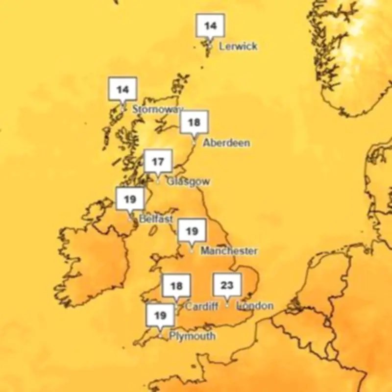
Met Office weather maps show highs of 27C in London and its surrounding areas on Sunday, June 14, and 25C in Greater Manchester. The location-specific forecast for Manchester, however, shows highs of 26C on the same day.
Detailed forecast for Greater Manchester
In the run-up to the weekend, temperatures are forecast to remain in the mid to high teens in Greater Manchester. The forecast predicts highs of 16C on Monday, June 8, 14C and 15C on Tuesday and Wednesday, June 9 and 10, 16C on Thursday, June 11, before rising to 19C on Friday, June 12, and 22C on Saturday, June 13.
Met Office spokesman Grahame Madge told the M.E.N.: "From the weekend, the forecast shows a return to more settled conditions for much of the UK. Temperatures in the North West are expected to reach 26C and this spell is expected to last at least a few days. Whether the conditions reach heatwave thresholds is still in the balance, but that shouldn’t detract attention away from what will be a fine spell for many."
Long-range forecast: unsettled start, then settled
The long-range forecast, covering June 12 to 21, warns of 'unsettled' weather conditions early on. The Met Office says: "Probably remaining fairly unsettled early in this period with Atlantic low pressure systems passing to the north and west of the UK. These will bring showers or longer spells of rain at times. The wettest conditions will be in the northwest, with more in the way of drier interludes in the southeast. Strong winds may affect parts of the UK at times, especially the northwest."
"Higher pressure and more settled conditions will likely become more established through the period, initially in the east or southeast, but perhaps becoming more widespread. There will probably still be some showers or longer spells of rain at times though. Temperatures are likely to be near or a little above normal overall."