
The United Kingdom is on high alert as advanced weather models predict a dramatic and disruptive bout of wintry weather, with two powerful Arctic blizzards set to bury parts of the country under as much as 30 inches of snow by the end of the week.
First Blizzard and Storm Goretti's Arrival
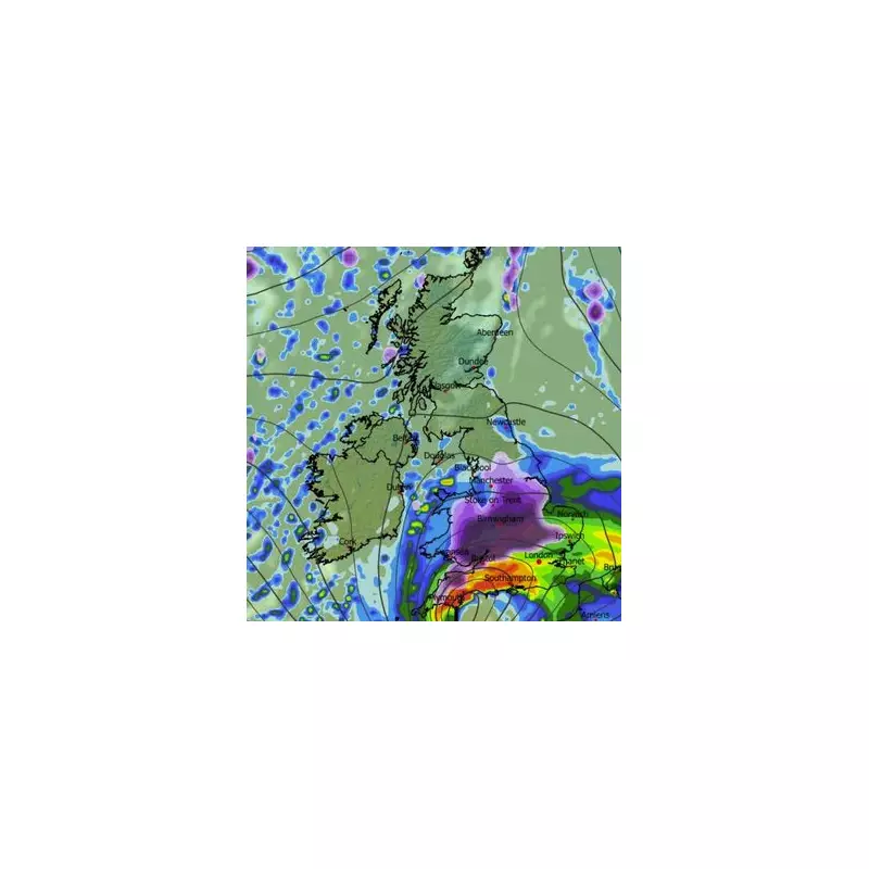
According to the ECMWF weather model, the first significant snow front will sweep across England and Wales from the south-west on Thursday evening, January 8. This system is expected to bring intense flurries, with snowfall rates potentially reaching one inch per hour. The south coast of England is also braced for heavy rain.
In response to the imminent threat, the Met Office has issued snow and wind warnings for Thursday, covering large parts of England and Wales. This weather front has been named Storm Goretti by the French meteorological service, Meteo France.

By midnight on Thursday, the snow is forecast to move eastwards, engulfing London, the Midlands, East Anglia, and the south-east. Northern England, Wales, and Northern Ireland may also see some flurries around this time.
Second Major Snow Front This Saturday
The wintry assault is not over after Thursday. The ECMWF data indicates a second, even more extensive snow front will sweep the entire length of the UK on Saturday, January 10. This system is predicted to bring snow across a 600-mile stretch, affecting cities from Dundee and Edinburgh in the north to Newcastle, Manchester, Birmingham, and London further south.
Most alarmingly, the modelling suggests snowfall rates in the north-west could reach a staggering four inches per hour during this event, posing a severe risk to travel and infrastructure.
Projected Snow Accumulations and Extended Outlook
Snow depth charts for midnight on Sunday, January 11, reveal the potential cumulative impact of these twin storms. The data suggests the most extreme accumulations will be in the far north of Scotland, where up to 78cm (approximately 30 inches) of snow could settle.
Other projected accumulations include:
- London: Around 5cm
- South Wales: Up to 28cm
- The Midlands: As much as 18cm
- The North-West: Potentially 21cm
Only the south-west of England and Wales, along with parts of Northern Ireland, are expected to escape significant snow cover.
The Met Office's longer-range forecast for January 10 to 19 indicates the volatile conditions are likely to persist. It states that Atlantic weather systems will bring further spells of rain, often preceded by snow, particularly in northern and eastern areas. The forecast warns of significant snowfall on northern hills and the potential for strong winds, interspersed with colder, drier interludes that could bring frost.


