
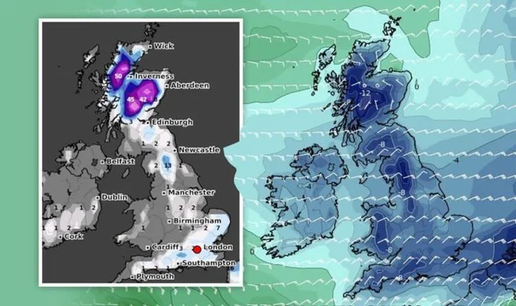
Ferocious easterly winds are predicted to strike throughout February, bringing 'disruptive snow' to the UK. Scotland could be hit with a staggering 145cm (4 feet) of snow on Thursday, February 11, according to the latest snow depth models from WCHARTS. The charts also show south-eastern parts of England being blasted with deep levels of snow during the second week of February.
Kent could see 5 inches (13cm) of snow, while Norwich faces 4 inches (11cm). London could also get a sprinkling of 3cm on Tuesday, February 9. North western parts of England, including the Yorkshire Dales and The Lake District, are expected to be hit with 8 inches (21cm) of heavy snow as early as Wednesday, February 3.
Temperatures could plummet as low as -12C in central areas of Scotland on Wednesday, February 10. Widespread cold is likely to plunge to -4C in London and the south east on the same day, while Cumbria in the north of England should be chillier at -5C.
Forecasters have warned the deep freeze could spark 'Beast from the East' chaos. Gavin Partridge, owner of GavsWeatherVids, predicted cold air from the east to engulf the UK from this week. He said: 'Later in the week we might pull in some very cold air from the east but there remains a lot of uncertainty about whether we'll open the door to The Beast.'
The BBC's long range forecast for next month also predicted cold air to push into the UK, potentially bringing a freeze similar to the Beast from the East in 2018. The Met Office's forecast between Saturday, February 13 and Saturday, February 13 added that 'disruptive snowfall' could strike towards the end of the month.




