
A significant earthquake with a magnitude of 3.4 struck the United Kingdom, sending tremors through numerous towns and cities and waking residents across the nation. The seismic event, which occurred late on Wednesday night, has been mapped in detail, revealing the surprisingly wide geographical area that felt the ground shake.
Epicentre and Immediate Impact
The British Geological Survey (BGS) confirmed the earthquake's epicentre was located in Lancashire. The tremor hit at 11.23pm and was recorded at a depth of approximately 10 kilometres. Dozens of people reported being abruptly awakened by the shaking, with some contacting police to report what they described as sounds resembling "explosions".
According to the BGS, the impact was primarily felt "across the South Lakes and Lancashire, mainly within 20km of the epicentre". However, data collected by seismic monitoring organisations tells a much broader story of the event's reach.

Nationwide Reach of the Tremor
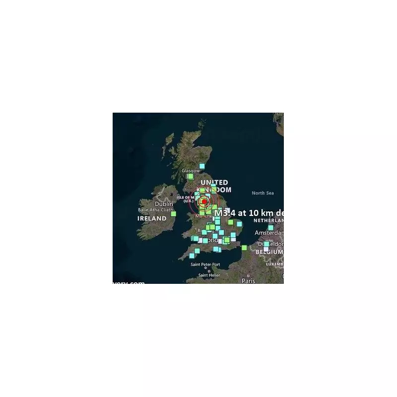
A new map published by VolcanoDiscovery, an organisation that tracks global volcanic and seismic activity, illustrates the extensive footprint of the earthquake. Despite its moderate magnitude, reports of the tremor flooded in from locations hundreds of miles from Lancashire.
Residents in major urban centres like Glasgow, Manchester, and the Midlands all reported feeling the quake. Remarkably, the effects were also noted as far south as London and Devon, and to the west in south Wales. This widespread sensation highlights how seismic waves can travel significant distances across the UK's geological structures.
Public Reaction and Scientific Context
The late-night timing of the event amplified its impact on the public, with many taking to social media and official reporting tools to share their experiences. While a magnitude 3.4 earthquake is considered light and rarely causes significant damage, it is certainly strong enough to be felt distinctly indoors, especially by those at rest.
Earthquakes of this scale in the UK serve as a reminder of the country's complex, though generally stable, geology. They provide valuable data for seismologists at the British Geological Survey, who continuously monitor such activity to better understand fault lines and assess seismic hazards across the British Isles.
This event underscores that while the UK is not located on a major tectonic plate boundary like the Pacific Ring of Fire, it is still subject to occasional seismic activity that can capture national attention and momentarily rock communities from coast to coast.


