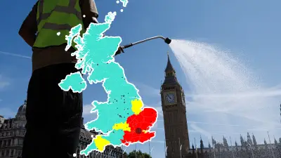
Temperatures are set to surge above 20C in 27 UK counties next week, with the Met Office predicting highs of 24C in some parts on Wednesday. The warm spell follows the snow, rain and wind brought by Storm Dave over the Easter weekend, which caused road closures and train disruptions but has now passed.
The Met Office said the mercury could rise to 24C in southern England on Wednesday, with the UKV weather model showing a large swathe of England experiencing temperatures of 20C or above. The warmest conditions are expected in the south, south-east, east, and the Midlands.
Met Office meteorologist Greg Dewhurst said: “On Tuesday, warmer air moves in across England and Wales from the near continent through Tuesday and into Wednesday. We will see temperatures rising to the low 20s, with highs around 20C or 21C on Tuesday, and possibly 23C or 24C come Wednesday. The sunniest skies on Wednesday may be limited to south-east England, where 23C and 24C is most likely.”

Tuesday’s forecast predicts highs of 18C in the north and 23C in the south, while Wednesday is expected to see northern areas reach 19C and southern areas hit 24C. All weather warnings have now been lifted after Storm Dave’s disruption.