
Dramatic new weather modelling has pinpointed the exact date a substantial snow system is forecast to sweep across the United Kingdom, potentially depositing more than 30 centimetres of snow in some regions. This comes as a sharp temperature drop is predicted, shifting from mild conditions to a deep freeze.
Precise Timing and Path of the Incoming System
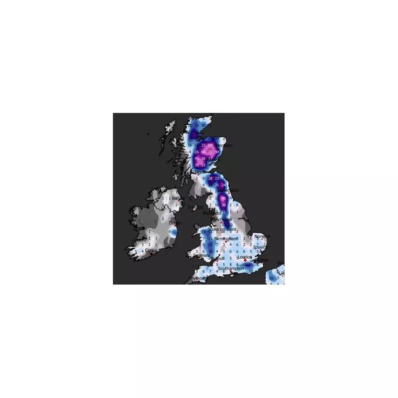
According to data visualised by WXCharts, which utilises information from MetDesk, the significant weather event is projected to make landfall from the west on the evening of January 27. The system, spanning several hundred miles, will initially bring a mix of rain and snow to southwestern areas, including Devon and Cornwall, as well as southern Wales.
Intensifying Snowfall and Eastward Movement
The snowfall is expected to intensify over the subsequent days. Initial rates could reach up to 1 millimetre per hour, with temperatures forecast to drop between 0°C and -2°C, allowing for accumulation. By January 29, precipitation could intensify to around 2 millimetres per hour, affecting cities such as Plymouth, Poole, and Exeter along the south coast.

Over the weekend of January 31, the mass of snow is predicted to drift eastwards, blanketing a large portion of the southeast. Areas from London and Bristol to Southampton, Ipswich, and Norwich, extending towards the outskirts of Manchester, could see between 0.2mm and 0.4mm of snowfall. The system is then forecast to push further north, reaching Newcastle by February 3 with similar snowfall amounts.
Projected Snow Depths and Regional Impacts
By February 4, total snow depth accumulations are expected to vary significantly. London and the broader southeast could see between 1cm and 15cm, with Kent potentially receiving the highest amounts in that region.
Heaviest Snowfall in the North
The most substantial snow totals are anticipated in northern England and Scotland. The Scottish Highlands could be buried under a massive 60 centimetres—more than two feet—of snow. Similarly, high-altitude areas like the North Pennines National Landscape and the Yorkshire Dales National Park may face accumulations looming around 45 centimetres.
Met Office Long-Range Forecast Context
The Met Office's long-range forecast for the period spanning January 25 to February 3 provides broader context. It suggests that while the period will see weather systems attempting to move in from the Atlantic, they may stall near the UK due to high pressure to the north and northeast.
This setup is likely to result in further spells of rain or showers, which could be heavy and persistent, particularly in the south and west. The forecast notes that while mild conditions may briefly encroach into the south and southwest, a general trend towards colder weather is expected. This colder shift brings the risk of some snow showers, most probable across hills in Scotland and northern England.
The forecast period aligns closely with the snow maps, indicating a period of volatile and potentially severe winter weather as the month concludes and February begins.


