The Met Office has confirmed that hot summer temperatures are set to return to the UK within days. New weather maps show temperatures climbing into the high 20s across parts of England and Wales later this week.
Hottest Areas on Friday
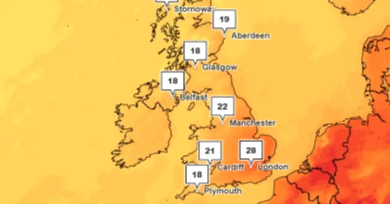
According to the latest forecast charts, London and surrounding counties could reach a sweltering 28C by 4pm on Friday, June 19. Much of southern and central England will enjoy temperatures above 20C. The Met Office temperature maps for 4pm on June 19 show the hottest conditions concentrated across southeast England, while Scotland and Northern Ireland remain noticeably cooler.
By 7pm, temperatures remain remarkably high, with London still forecast to be at 27C. Manchester is expected to hold onto 21C, while Cardiff stays close behind at 20C.

Full List of 8 Hottest UK Areas at 4pm on June 19
- London – 28C
- Manchester – 22C
- Cardiff – 21C
- Aberdeen – 19C
- Plymouth – 18C
- Glasgow – 18C
- Belfast – 18C
- Stornoway – 15C
Rain and Cooler Conditions Ahead
However, the hot conditions are not expected to last. Rainfall maps for June 19 show bands of wet weather pushing into the southwestern parts of the UK. Showers and outbreaks of rain are forecast to spread northeastwards, bringing cooler conditions and taking the edge off the heat. The heaviest rain will affect parts of the southwest and the Irish Sea coast.
As the rain arrives, temperatures are forecast to fall noticeably. While some eastern and southeastern areas could remain very warm, maximum temperatures are expected to peak closer to 26C on June 20.
Met Office Forecast Summary
In its outlook for Wednesday (June 17) through to Friday, the Met Office forecast reads: "Rain clearing to sunshine and showers Wednesday. The northwest will see further rain at times through Thursday and Friday. Mostly dry towards the southeast, turning very warm and humid here."
Long-Range Forecast
The Met Office's long-range forecast for the period June 19 to June 28 states: "There is the possibility of some hot and humid weather across parts of south and southeast Britain at the start of this period and with it comes the chance of a few thunderstorms too. To the northwest of here, generally more changeable at first, but there is a signal for high pressure to build more widely as we move towards the latter part of June. This could bring more widely drier, settled conditions with temperatures probably remaining above average for most.
"There is chance however that the hot conditions, initially in the south could either linger here or, having waned for a time, return northwards accompanied by a thunderstorm risk; this all dependent on the orientation of the aforementioned high pressure."
Regarding its long-range forecasting, the Met Office warns: "When looking at forecasts beyond five days into the future, the chaotic nature of the atmosphere begins to play a larger part - small events currently over the Atlantic can have potentially significant impacts on our weather in the UK and Ireland in several days' time."