
UK Braces for Prolonged Blizzard with Intense Snowfall Rates
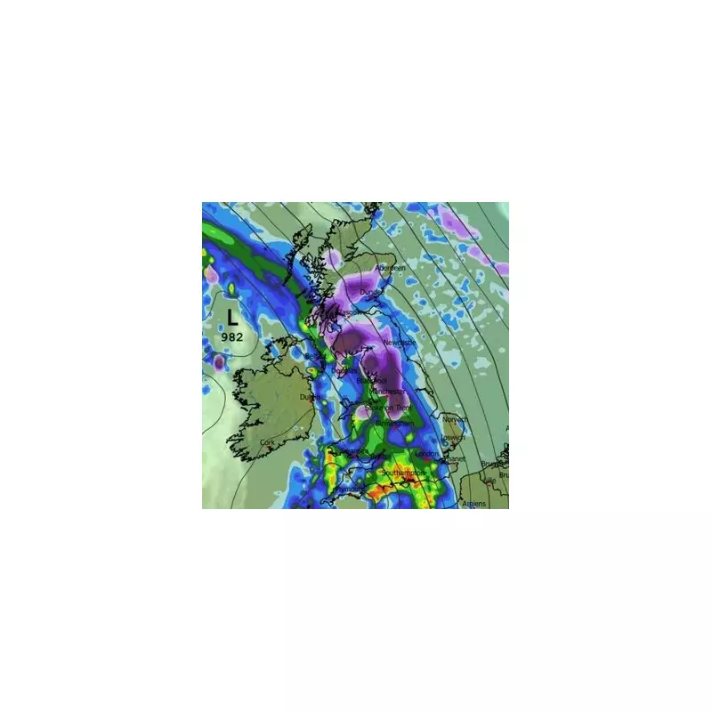
Britons are being warned to prepare for a significant winter storm as advanced meteorological modelling indicates an 18-hour blizzard could sweep across the country next week. Weather forecasting maps reveal the potential for snowfall rates reaching an astonishing four inches per hour in some regions, with the disruptive weather event expected to commence in the early hours of Tuesday.
Timeline of the Approaching Winter Storm
The meteorological event is forecast to begin with snow starting to fall from approximately 3am next Tuesday. Initial flurries are predicted to affect Wales, the Midlands, northern England, and Scotland, with data suggesting snowfall rates of around one inch per hour in the most intense areas, particularly over elevated terrain.
As the morning progresses, conditions are expected to deteriorate significantly. The Peak District could experience particularly severe conditions around 9am, with snowfall intensifying to four inches per hour. Major urban centres including Manchester and Birmingham may find themselves directly in the storm's path as the snow spreads to lower-lying regions. While some parts of southern England might see wintry precipitation, most southern areas are more likely to encounter heavy rainfall instead.

Afternoon and Evening Intensification
By 3pm, European Centre for Medium-Range Weather Forecasts (ECMWF) model data suggests the snowfall will become more sporadic. Nevertheless, pockets of wintry showers are still anticipated to impact numerous regions including the south-west, East Anglia, Wales, Northern Ireland, and parts of northern England and Scotland.
The evening could bring another dangerous escalation in weather conditions. Forecasts indicate that snow may intensify once more over Yorkshire and the Pennines, with data projecting that by 9pm, northern England could again experience snowfall rates approaching four inches per hour.
Expected Snow Accumulations Across the UK
Snow depth charts provide crucial insights into where significant settling is likely:
- Scottish Highlands: Potentially up to 69cm of accumulation
- Northern England hills: Approximately 24cm expected
- Wales: Forecasts suggest around 7cm
- Northern Ireland: An estimated 2cm anticipated
Despite some flurries potentially reaching southern regions, significant settling is considered unlikely in these areas according to current projections.
Official Weather Service Forecasts
The Met Office has indicated that snow remains a distinct possibility as we move into next week. Their forecast for the period from Sunday to Tuesday states: "Remaining unsettled throughout, with bands of rain moving north and east across the country. Gradually turning colder from the northeast, with an increasing risk of snow, particularly over northern hills."
Looking further ahead from Wednesday until February 6, Met Office forecasters explain: "Weather systems moving in from the Atlantic will continue to attempt to push in from the west, but tending to stall in the vicinity of the UK as they encounter high pressure to the north and northeast. As a result, further spells of rain or showers are expected at times."
They add: "These may be heavy and persistent, especially in the south and west. Whilst mild conditions are expected to encroach into the south and southwest at times, cold air is likely to be positioned to the northeast, bringing wintry showers at times. Where fronts from the south west do reach the cold air towards the north east, there is the risk of some snow, most likely across hills, but perhaps extending to other areas at times."
Additional Meteorological Perspectives
BBC forecasters corroborate the potential for disruptive winter weather, stating: "A band of rain should push into western and southwestern areas later. As this edges farther north and east overnight and into Tuesday, some snow should develop over north Wales, northern England and Scotland, mainly over higher ground."
Their extended outlook suggests: "Another band of rain and hill snow could move in from the south-west at some point in the second half of the week, with brighter and more showery conditions before and after."

This developing weather situation underscores the importance for residents across affected regions to stay informed through official weather channels and prepare appropriately for potential travel disruption and hazardous conditions.


