Nearly 50 million people across the United States are in the path of severe weather outbreaks, just days after tornadoes left parts of the South in ruins and killed at least one person. Millions across the Midwest and Great Plains have been placed under emergency alerts for severe weather, including tornadoes, as a violent storm system is expected to persist from Sunday into Monday.
States at Risk
Twelve states are at risk for potentially deadly weather: Illinois, Indiana, Iowa, Kansas, Michigan, Minnesota, Missouri, Nebraska, North Dakota, Ohio, South Dakota, and Wisconsin. The latest warning was issued just before 7:30 p.m. Sunday for Wichita, Kansas, where a 'large, extremely dangerous tornado' was confirmed about six miles south of Neodesha and moving east at 20 mph, according to the National Weather Service (NWS).
'This is a PARTICULARLY DANGEROUS SITUATION. TAKE COVER NOW!' the alert read. A flood watch has also been issued for areas in Kansas City and St. Joseph, Missouri, where rainfall of two inches or more is possible.

Expert Warning
'Tornadoes that strike after dark or are wrapped in rain are especially dangerous because they can be nearly impossible to see,' Tyler Roys, a senior meteorologist at AccuWeather, said in a statement. 'Everyone in the region should be ready to act quickly and have multiple ways to receive warnings and alerts that can wake you overnight.'
Storms have battered the central United States over the past week, bringing more than 30 tornadoes and more than 230 reports of hail, according to AccuWeather. Sunday's alert comes just hours after several twisters swept through parts of Mississippi and Texas, ripping roofs from homes and leaving residential areas reduced to debris.
Deadly Tornadoes in Texas
In the afternoon, a tornado with winds reaching 105 mph touched down in the Springtown area of Texas and tore through the community for 32 minutes, covering nearly 10 miles. One person was killed by the winds, according to NBCDFW News. Late Saturday, at least 12 unconfirmed tornadoes were reported across parts of the Plains and Southwest, including five in Texas, six in Oklahoma, and one in Nebraska. Hail, described as larger than baseballs, was also reported in Texas and Arkansas on Saturday.
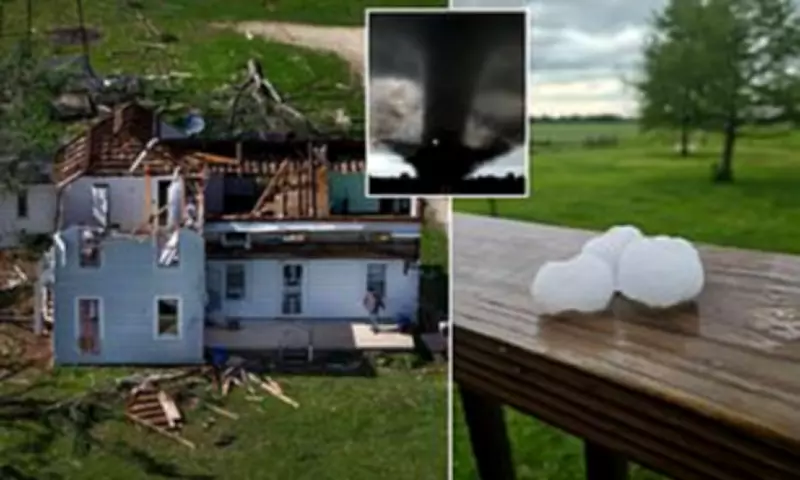
In Runaway Bay, Texas, a 'supercell thunderstorm' unleashing baseball-sized hail and powerful wind gusts helped spawn a tornado with peak winds reported at 135 mph. One person was killed as a result of the twister, with several others injured and at least 20 families displaced, according to county officials. The same storm also spawned a second tornado in nearby Shannon.
Damage Assessments
Parker County ESD #1 Assistant Fire Chief David Pruitt described the scene based on footage captured by the Texas Sky Ranger, which hovered over both Runaway Bay and Springtown. He said video showed 'a field of debris covered by splintered wood, collapsed roofs, and downed walls' in Runaway Bay, while in Springtown, 'homes were leveled and vehicles were overturned.' At least 10 people were injured after a powerful tornado struck northern Oklahoma on Thursday night, leaving around 40 homes damaged and causing light damage at a nearby Air Force base, according to The Guardian.
Severe Weather Forecast
On Sunday, a Level 3 out of 5 'enhanced risk' of severe weather was predicted for much of Kansas and parts of western Missouri and southeastern Nebraska, including Wichita, Kansas City, Missouri, and Beatrice, Nebraska. The NWS warned that tornadoes, damaging winds, and large hail are all possible. 'There is some potential for significant severe weather: very large hail around 2 inches in diameter, damaging winds up to 70 mph, and a few tornadoes,' the NWS alert read. 'A strong tornado is possible across mainly south central and southern Kansas.'
A Level 2 out of 5 'slight risk' of severe weather was forecast for parts of northern Texas, northwest Arkansas, western Missouri, southwest Iowa, southern Nebraska, most of Oklahoma, and Kansas, according to the NWS. On Monday, the severe weather threat is expected to spread northeastward, reaching from the lower Mississippi Valley into the Midwest.

Multiple cities were alerted to prepare for an 'enhanced risk,' or a Level 3 out of 5, of severe weather: St. Louis, Cedar Rapids, Jonesboro, Evansville, Paducah, and Rockford. Memphis, Chicago, Milwaukee, Louisville, South Bend, and Mason City are all forecast to face a Level 2 out of 5 'slight risk' on Monday, which could bring tornadoes, widespread damaging wind gusts, large hail, and spotty flash flooding. Monday's storm system is expected to dump heavy rain across the central US, raising the risk of isolated flash flooding, with additional heavy rainfall expected in the Great Lakes region.