


Entertainment

Flavio Cobolli Joins PSG's Champions League Celebrations at Roland Garros
Italian tennis star Flavio Cobolli joined PSG players in celebrating their Champions League triumph at Roland Garros, before advancing to the French Open quarter-finals.


Politics

Mandelson Criticised Starmer's Leadership in Leaked Messages
Lord Mandelson said No 10 needed a 'complete revamp' and that Keir Starmer 'lacks verve' in WhatsApp messages released among thousands of documents from his time as UK ambassador to the US.


Sports

Anthony Joshua's Comeback Fight Venue Changed to Jeddah Superdome
Anthony Joshua's fight against Kristian Prenga on July 25 has been moved from Riyadh to the Jeddah Superdome, setting up a potential clash with Tyson Fury.


Crime

Paddleboarder and Dog Rescued from Cliff During Lightning Storm
A woman and her dog were rescued from a cliff base during a severe lightning storm after her paddleboard deflated, leaving them stranded in treacherous conditions.


Health


Environment

Thousands Flock to U-M Historic Peony Garden
Tens of thousands visit the University of Michigan's W.E. Upjohn Peony Garden annually to see one of North America's largest collections of historic herbaceous peonies.

Louisiana Balloon Release Ban: Fines Up to $2,500
Louisiana has passed a law banning intentional outdoor balloon releases, effective August 1. Violators face fines up to $2,500 and community service. Environmentalists support the ban, while some critics argue it hinders grief expression.

England and Wales Warmest Spring on Record
England and Wales recorded their warmest spring since 1884, driven by an exceptional late-May heatwave. Nine of the ten warmest springs in England have occurred since 2007.
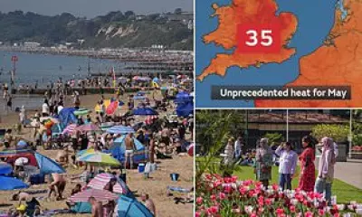
Spring 2025 Hottest on Record in England and Wales
Spring 2025 was the warmest in England and Wales since records began in 1884, with a mean temperature of 10.41°C. Nine of the ten warmest springs have occurred since 2007.
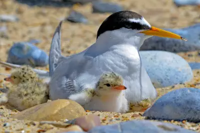
Shorebirds Thrive on Lindisfarne: Terns and Plovers
Conservation efforts on Lindisfarne's Holy Island have led to a resurgence in tern and plover populations, showcasing successful shorebird protection strategies.
UK Geography Quiz: Test Your Knowledge
Challenge yourself with 100 multiple-choice questions about the geography of the United Kingdom. Perfect for students, travelers, and geography enthusiasts.
