
Britain is on high alert for a significant snow bomb set to strike in early December, with advanced meteorological models predicting that some major towns and cities could be buried under up to 10cm (four inches) of snow.
When and Where the Snow Will Strike
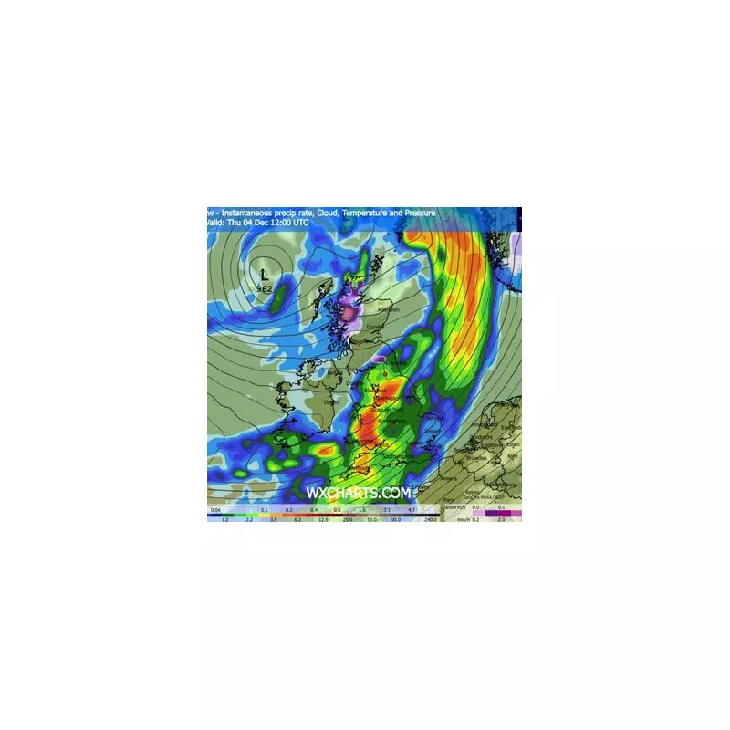
According to detailed GFS model maps, a major weather front will sweep across the entire UK in the early hours of December 4. This initial system is forecast to bring widespread rain to Northern Ireland, Wales, England, and southern Scotland. However, central and northern parts of Scotland are expected to bear the brunt of the first wave, with intense snowfall likely.
By midday on December 4, the modelling indicates that all of England and Wales will be experiencing heavy rain, while north-west Scotland continues to see snow. The situation is set to escalate dramatically the following day.

Second Storm Brings Widespread Snow Risk
A second, potent weather front is predicted to arrive on December 5, dramatically expanding the snow risk. Forecasts suggest that light snow will begin to fall across Northern Ireland around midday, with far heavier snow hitting Ireland, particularly Dublin.
In England, the snowfall is expected to initially centre around the Yorkshire Dales and the Pennines before spreading throughout the day, potentially affecting more densely populated areas.
Official Forecasts Warn of Wintry Hazards
The Met Office has corroborated these predictions in its outlook for late November to early December. It warns of changeable and unsettled conditions dominated by low-pressure systems, bringing showers and longer spells of rain.
The national forecaster states, "Some heavy rain or showers are expected, most often in the west... Snow will probably be confined to high ground in the north." It also highlights the risk of strong winds, especially around coasts.
In a contrasting but cautious forecast, BBC Weather suggests high pressure may bring drier conditions for most during the first week of December. However, it notes that "a couple of Atlantic frontal systems should nudge towards the UK," bringing rain mostly to northern and western regions, with wintry precipitation possible over Scottish high ground.
The BBC also acknowledges a risk that if high pressure positions itself differently, colder flows could develop, increasing the potential for more widespread wintry weather. The nation is advised to stay updated on the evolving forecast as the potential snow bomb approaches.


