
The United Kingdom is preparing for a significant wintry onslaught as fresh weather data indicates a major Arctic weather front will sweep across the country in early December, potentially burying parts of Britain under up to seven inches (17cm) of snow.
Major Snowstorm Timeline
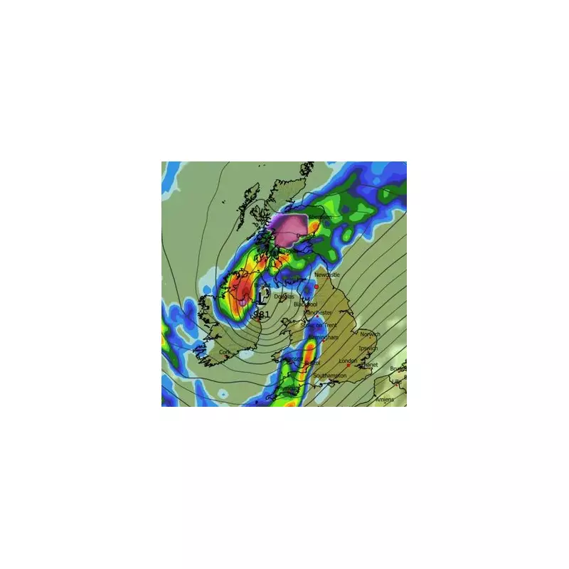
Advanced meteorological modelling maps reveal another snowstorm is merely days away from impacting the nation. The GFS model charts show a potent weather system moving in from the Atlantic, initially striking Northern Ireland and Scotland in the early hours of December 3.
While central and northern regions of Scotland are expected to bear the brunt with heavy snowfall, Northern Ireland looks set to experience intense rainfall instead. As the day progresses, the snow is forecast to slowly advance southward.

By midday on December 3, weather maps illustrate snow flurries of 1cm per hour drifting towards the Scotland-England border. The wintry conditions are then projected to reach the far north-east of England by approximately 3pm that same day.
Second Weather Front Intensifies Conditions
A secondary weather front is then tracked to follow closely behind, moving in from the Atlantic in the early hours of December 4. This system is predicted to target Wales and central England directly.
Meteorological data suggests North Wales will experience a brief period of intense snow, while other regions within this front's path will likely contend with heavy rain. The cumulative effect of these consecutive systems could lead to substantial accumulations, particularly in elevated areas.
Projected Snow Accumulations and Official Forecasts
Snow depth analysis indicates the potential for significant build-up, with the Cairngorms National Park in Scotland potentially seeing up to 17cm of snow settling on the ground following this Arctic blast.
More modest accumulations of up to 1cm are possible in Northern Ireland, North Wales, and southern parts of Scotland. These projections align with official forecasts from national weather services.
The Met Office has acknowledged the potential for snow in its outlook for the start of December. Their forecast for the period from November 28 to December 8 states: "Changeable and unsettled conditions are expected across the UK during this period. Low pressure systems will tend to dominate meaning showers or longer spells of rain for much of the UK, though there will likely be some brief settled interludes."
Regarding frozen precipitation, the Met Office adds: "Snow will probably be confined to high ground in the north," indicating alignment with the weather models showing significant accumulation in Scotland's mountainous regions.
Meanwhile, BBC Weather's forecast for December 1-7 suggests: "Although most regions should be drier than normal, a couple of Atlantic frontal systems should nudge towards the UK, bringing occasional rain chances, mostly to northern and western regions, and probably most especially for Scotland, where some wintry precipitation could be possible over high ground."
The meteorological service also notes a risk that high pressure could position itself differently, potentially over Scandinavia, which would increase the chances of colder flows developing across Britain - a scenario that could intensify and prolong the wintry conditions.


