Weather maps are indicating a surprising late-season surge of wintry weather could blanket parts of the United Kingdom later this month, with forecasts showing snow and brief blizzard-like conditions targeting northern regions. This cold snap is expected to arrive around Tuesday, April 22, and persist for several days, creating a stark contrast to the milder spring temperatures experienced elsewhere in the country.
Forecast Details and Affected Areas
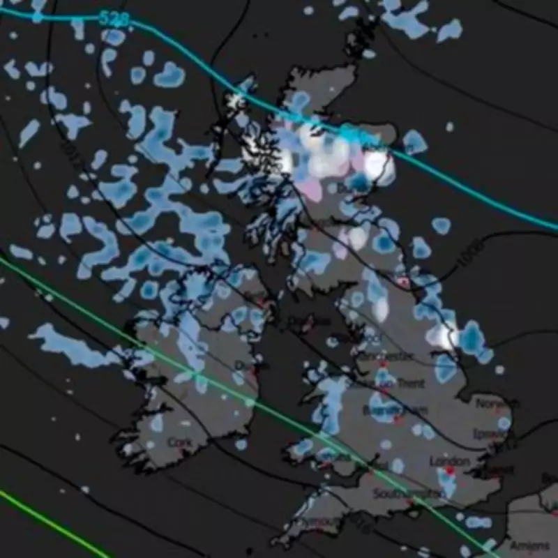
According to detailed charts from WXCharts, the most severe conditions are likely to be concentrated across northern and higher-altitude areas. The forecast suggests that snow showers, combined with powerful winds, could lead to temporary blizzard conditions, particularly over exposed terrain. Temperatures in these affected regions are projected to plummet sharply, with daytime highs ranging between 2C and 6C during the coldest periods. Overnight lows could tumble to 0C or below, increasing the risk of frost and hazardous icy surfaces on roads and pathways.
List of Areas at Risk
The following areas have been identified as most at risk of experiencing snowfall and blizzard-like conditions during this period:

- Scotland: Sutherland, Caithness, Ross and Cromarty, Inverness-shire, Nairnshire, Moray, Banffshire, Aberdeenshire, Angus, Perthshire, Argyll
- England: Northumberland, County Durham, Cumbria, North Yorkshire
Regional Weather Divide
While the North braces for cold and snow, southern parts of the UK are expected to remain considerably milder. Forecasts indicate temperatures in southern and western England could reach between 12C and 18C, with more settled and warmer conditions prevailing. This stark divide is being driven by Atlantic weather systems moving in from the West, which are being held at bay by high pressure to the North-east.
Met Office Outlook
The Met Office has provided additional context for the period from Sunday, April 19 to Tuesday, April 28. Initially, many areas are expected to start largely dry, with spells of warm sunshine, particularly on Sunday. However, as the week progresses, fronts associated with another Atlantic low will attempt to push into the UK but may struggle against the persistent high pressure to the North-east.
This pattern suggests that much of the following week will feature plenty of dry weather with sunny spells, though east coasts could feel chilly. Toward next weekend and beyond, conditions are likely to turn more unsettled, with a return of rain or showers for many regions.
Broader Implications and Uncertainty
Despite the forecast charts pointing to a brief spell of wintry conditions across northern regions, the broader outlook remains uncertain. As April continues, the UK can anticipate a mix of sunny intervals, cooler conditions along coastal areas, and intermittent unsettled periods. This late-season snow event serves as a reminder of the unpredictable nature of British weather, even as spring advances.