
UK Braces for 24-Hour Snow Storm as Temperatures Plummet This Week
Britain is set to be hit by a 24-hour snow storm this week, with freezing temperatures and significant snowfall forecast across most areas. According to the latest weather maps from WXCharts, the storm will commence from midnight on Saturday, February 14, and persist throughout February 15, bringing a blanket of snow to the majority of the UK.
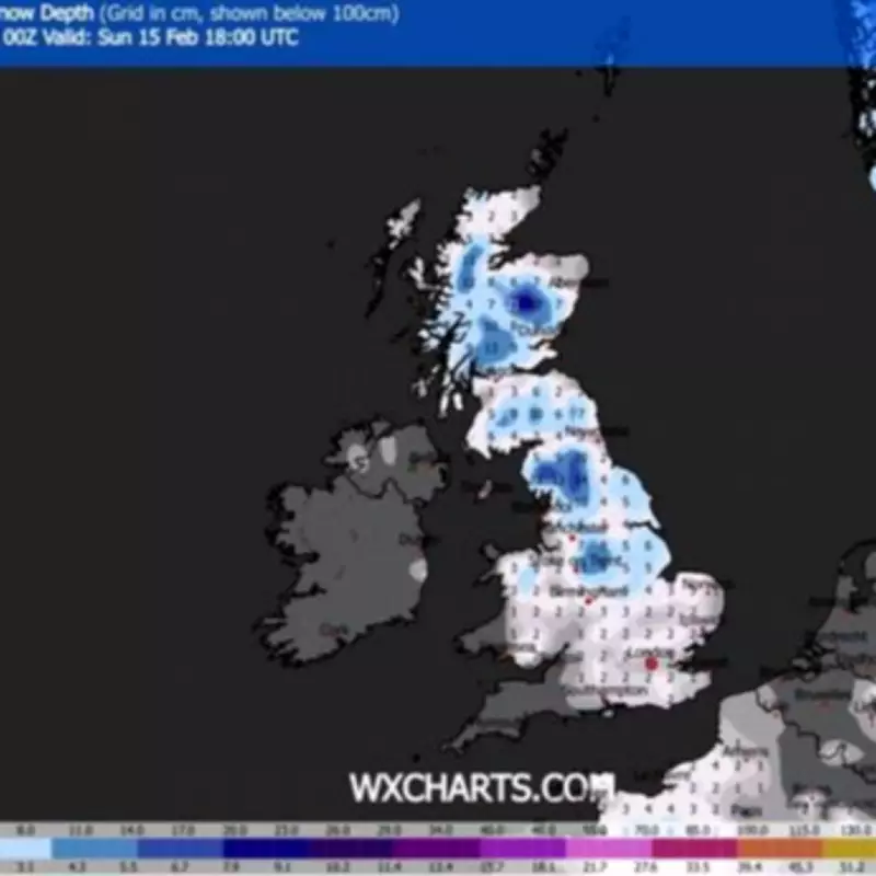
Snowfall Forecast and Affected Regions
Maps indicate that snowfall will initiate from the west and progress eastward during the day. Most regions can expect around 2cm of snow, but heavier accumulations are predicted in specific areas:
- Peak District: Moderate snowfall expected.
- Yorkshire Dales: Up to 6cm of snow forecast.
- Cairngorms: Significant accumulation of up to 16cm anticipated.
However, some areas will remain unaffected, including Buckingham and Oxfordshire, the East Midlands, East Yorkshire, East Anglia, western Wales, Cornwall, Sussex, the West Midlands, Manchester, and parts of the northwest.

Met Office Outlook and Warnings
The Met Office has issued a detailed forecast, highlighting a shift from unsettled, rainy conditions to colder, brighter weather by Friday, with snow showers likely, particularly in northern and eastern regions. For the period from Saturday, February 14 to Monday, February 23, the forecast suggests:
"After a briefly quieter spell associated with colder conditions, Atlantic frontal zones are expected to return, bringing broadly unsettled weather with further spells of rain and potential strong winds. While milder conditions may prevail for many, colder spells could intermittently affect northern and northeastern parts."
This week, wet weather continues, with a yellow weather warning in place for much of southern Wales and England on Monday, alerting nearly 100 areas to possible flooding. This follows a record-breaking wet January, notably in Cornwall and County Down.
Additional Weather Alerts and Impacts
A separate yellow warning for heavy rain and flooding is active across a large part of Scotland, from Perth to Aberdeen, from 9am on Tuesday until Wednesday evening. Drivers are advised to prepare for difficult conditions and potential road closures, with snow expected on higher roads by Tuesday's end.
A Met Office spokesperson stated: "Rain, heavy at times, will persist across eastern Scotland during Wednesday, likely causing disruption and possible flooding. An additional 20-30mm may fall widely, with 40-60mm possible over high ground. As freezing levels lower from the north, snow is likely above 300-400 metres, especially in Aberdeenshire, Angus, and Perthshire, where 5-10cm may accumulate by Wednesday's end."
In summary, the UK is on alert for a significant snow event this weekend, with widespread impacts expected. Residents are urged to stay updated on local forecasts and prepare for potentially hazardous travel conditions.


