Snow Maps Predict Surprise March Blizzard to Sweep UK Cities
Shocking new weather forecasting maps suggest a significant blizzard could sweep across the United Kingdom in mid-March, with major cities directly in the firing line. The unexpected snow event is predicted to arrive as temperatures plummet across the nation.
GFS Model Details Widespread Snow Event
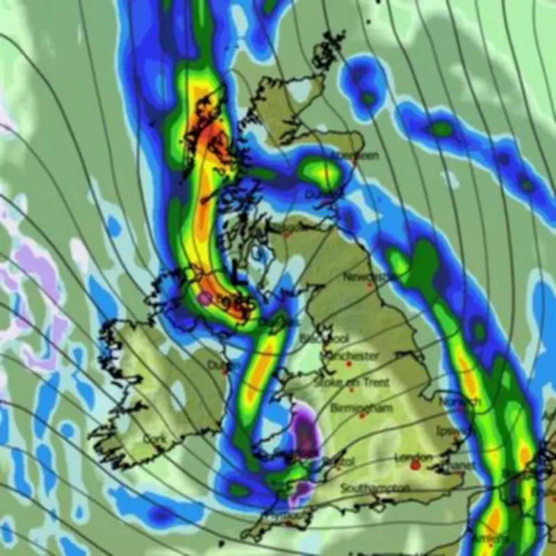
The GFS weather model indicates a powerful storm system will move in from the Atlantic Ocean on March 14, initially bringing widespread rain to most regions. However, the precipitation is expected to fall as snow across south-west England, Wales and Northern Ireland at the onset of the system.
By 9pm on March 14, weather maps show significant snow accumulation indicated by purple areas covering North Wales, the Midlands and north-west England. Urban centers including Stoke and Manchester could experience substantial snowfall, creating potential travel disruptions and hazardous conditions.

Northern Expansion and Temperature Drop
The snow system is then forecast to continue moving northward throughout the evening. By midnight on March 14, western parts of Scotland are expected to see snow impacts, with additional flurries potentially affecting Manchester, north-east England and the North Pennines region.
Temperature data accompanying the forecast suggests values could drop to just 2°C or 3°C quite widely across the UK, creating ideal conditions for snow accumulation rather than melting precipitation. This represents a significant temperature plunge for mid-March when milder conditions would typically be expected.
Met Office Forecast for Late March
The Met Office has acknowledged the possibility of some snow later in March, though their official forecast suggests wintry showers will likely be confined to northern hills rather than widespread urban areas. Their outlook for March 13 to 27 indicates changeable conditions resuming by mid-March.
The Met Office states: "Atlantic frontal systems spreading across all of the UK at times will bring spells of rain and perhaps strong winds, with the wettest conditions likely in the northwest. Some hill snow is possible in the north too. Temperatures are likely to be near or slightly above normal overall."
BBC Weather's Cautious Outlook
BBC Weather forecasters have noted the potential for "chiller outbreaks" in March but emphasize it remains too early to predict exactly how cold conditions might become. Their forecast for March 9 to 22 suggests the UK will likely be situated between European high pressure and Atlantic low pressure systems.
The BBC outlook indicates: "Occasional rain and brisk winds are likely, with near average precipitation amounts expected. Milder than average conditions are expected overall, though there is a slight possibility of high pressure building at higher latitudes in the second half of March, which would bring a chance of some chiller outbreaks."
Both weather agencies agree that while some colder conditions are possible in March, significant early spring cold remains speculative at this forecasting range. However, the GFS model presents a more dramatic scenario with potential snow impacts reaching major population centers across England, Wales, Northern Ireland and Scotland.