New weather maps have revealed a shocking blizzard is poised to strike the United Kingdom within days, potentially burying cities under up to 11 inches of snow. The GFS weather model forecasts this unexpected March snowstorm will begin impacting regions from March 16, with heavy flurries expected to persist for hours.
Timeline and Impact of the Incoming Snowstorm
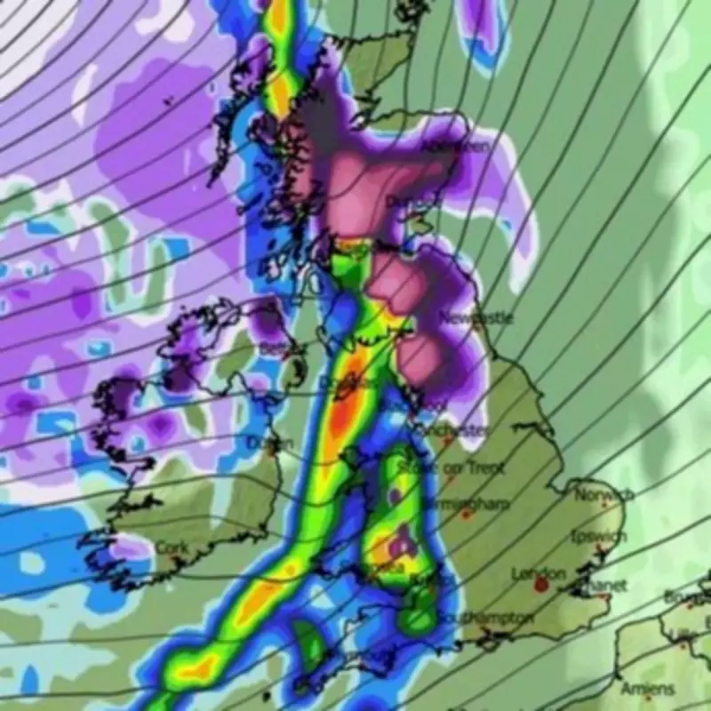
The storm is projected to initiate around 9pm on March 16, with snow first falling across Northern Ireland, Wales, northern England, and Scotland. Major urban centres including Belfast, Glasgow, Newcastle, and Edinburgh are all in the direct path of this wintry onslaught and could see significant accumulations of the white stuff.
Regional Snowfall Predictions and Accumulations
Data suggests the heaviest snowfall will concentrate in north-west England and Scotland, where hills could see as much as 27 centimetres, equivalent to 11 inches. Northern England may receive around 4 centimetres, or 1.5 inches, while other areas might see accumulations of 1 to 2 centimetres. By 6am on March 17, snow coverage maps indicate all of Northern Ireland and Scotland will have snow settled on the ground, with most of northern England and Wales also covered, and some flakes potentially reaching the Midlands.

Meanwhile, southern parts of the country are expected to be drenched by heavy rain instead of snow, creating a stark weather divide across the nation. As the storm progresses, maps show snow persisting over the Pennines and north-east England by midnight, and although flurries may weaken by 9am, Manchester could still experience impacts, with further snow likely in Northern Ireland and Scotland at that time.
Met Office Forecast and Broader Weather Context
The Met Office has also indicated the possibility of snow this month, though it suggests wintry showers will likely be confined to hills in Scotland and Northern Ireland. Its forecast for March 7 to March 16 notes that high pressure will maintain influence, especially in the south and south-east, leading to dry weather with variable cloud and sunshine in many areas.
However, the forecast cautions that frontal systems may still affect the north and west, potentially bringing rain, strong winds, and hill snow to the highest parts of Scotland and Northern Ireland. Temperatures are expected to be near or above normal, with some frosty nights still possible, underscoring the unpredictable nature of early spring weather in the UK.
This impending blizzard follows recent cold snaps and serves as a reminder that winter conditions can linger into March, disrupting travel and daily life across affected cities. Residents in northern regions are advised to stay updated on weather warnings as the storm approaches.