Aberdeen's Geothermal Future Mapped with Underground Sensor Network
In a pioneering move toward sustainable energy, researchers have begun installing a network of 100 seismic sensors beneath Aberdeen's surface to assess the city's geothermal heating potential. This ambitious project, led by the University of Aberdeen, aims to harness the Earth's natural underground heat—functioning like a vast, natural radiator—to provide low-carbon heating solutions.
Deploying Sensors Across the City
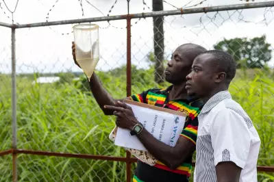
The sensors, also known as seismic nodes, are being strategically placed across a mix of public and private green spaces throughout Aberdeen. Measuring approximately 10cm x 10cm x 30cm, each device is discreetly covered with a thin layer of soil after installation by volunteers. Their placement spans from the Bridge of Don to Nigg, extending inland as far as Hazlehead, ensuring comprehensive coverage of the urban area.
These sensors will remain operational for one to two months, during which they will record natural and manmade vibrations from sources such as ocean waves, wind, and traffic. The collected data will be used to construct a detailed 3D subsurface map, probing depths of up to 5km beneath the city. This mapping is crucial for identifying optimal locations where geothermal heating could be most effective.

How Geothermal Heating Works
Geothermal heating operates by pumping water underground, where it is naturally heated by the Earth's internal warmth. The heated water is then circulated back to the surface to warm buildings, offering a renewable alternative to traditional heating methods. This process not only reduces reliance on fossil fuels but also aligns with global efforts to cut carbon emissions.
Project Funding and Collaboration
Titled the Aberdeen Geothermal Feasibility Pilot, this initiative is backed by a £1 million grant from UK Research and Innovation. It enjoys support from a consortium of organisations, including NHS Grampian, Aberdeen City Council, multiple universities, and the British Geological Survey. In addition to the sensor network, the project will involve drilling a 500-metre-deep borehole on the University of Aberdeen's King’s College Campus. This borehole will monitor temperature, geology, and hydrology, providing further insights into subsurface conditions.
Expert Insights on the Initiative
Dr Amy Gilligan, a key researcher on the project, expressed enthusiasm about this phase: "This marks the beginning of an exciting stage of the project. By placing these small sensors in the ground, we can safely and quietly listen to natural vibrations and build a picture of the rocks deep below Aberdeen." She added, "Most people won’t notice the sensors once they are in place, but what we learn will help us understand whether geothermal heat could one day provide a clean, local source of heating for homes and public buildings, reducing carbon emissions and supporting a more sustainable energy future for Aberdeen."
The data gathered will ultimately guide decisions on where geothermal systems can be implemented most efficiently, potentially transforming Aberdeen's energy landscape. This project underscores the city's commitment to innovation in renewable energy and positions it as a leader in exploring geothermal solutions for urban heating needs.