In a historic move that challenges centuries of cartographic tradition, the African Union, representing 55 member states, has unveiled a radical plan to redraw the world map. The ambitious initiative seeks to replace the widely used—and widely criticised—Mercator projection with the 'Equal Earth' projection, a map that accurately represents the true scale of continents.
The Mercator Misdirection
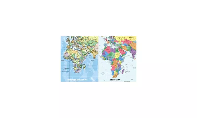
For over 400 years, the Mercator projection has dominated classrooms, boardrooms, and navigation systems worldwide. Created by Flemish cartographer Gerardus Mercator in 1569, this map severely distorts the size of landmasses nearer the poles, dramatically shrinking Africa while enlarging Global North nations.
The staggering reality: Africa, with its 30 million square kilometres, appears roughly the same size as Greenland on Mercator's map. In truth, Africa is a staggering 14 times larger. This misrepresentation, critics argue, has perpetuated a diminished view of the continent's vastness and potential for centuries.

The Equal Earth Solution
The proposed alternative, the Equal Earth projection, was developed in 2018 by cartographers Tom Patterson, Bernhard Jenny, and Bojan Šavrič. It retains the visual familiarity of the Mercator while presenting a far more accurate portrayal of continental sizes.
Key advantages include:
- True proportional representation of all land areas
- Minimal distortion of shapes
- A visually balanced and navigable world view
- Accurate depiction of Africa's immense scale
A Geopolitical Statement
This initiative transcends mere cartography; it represents a profound geopolitical statement. By advocating for the Equal Earth map, the African Union is actively confronting the lingering legacy of colonial-era perspectives that have long influenced global economics, politics, and cultural perception.
The move signals a growing assertiveness on the world stage, demanding not just political and economic equity, but also representational accuracy. It challenges the world to see Africa not through a Eurocentric lens, but through a lens of factual reality.
Implementation and Global Reception
The Union's strategy involves a multi-pronged approach:
- Lobbying for adoption within United Nations agencies and international bodies
- Encouraging member states to integrate the map into national educational curricula
- Engaging with global tech giants to feature the Equal Earth projection in digital mapping services
- Promoting its use in international media and publications
While the initiative has been met with enthusiasm by educational and cultural experts, it faces practical challenges. The Mercator projection's entrenchment in navigation systems, software, and public consciousness will require a significant, coordinated global effort to overcome.
This cartographic revolution, if successful, promises to fundamentally reshape how future generations perceive our world, finally giving Africa its rightful place on the map—both literally and figuratively.