
Island of Ireland Braces for Flooding and Snow Amid Severe Weather Warnings
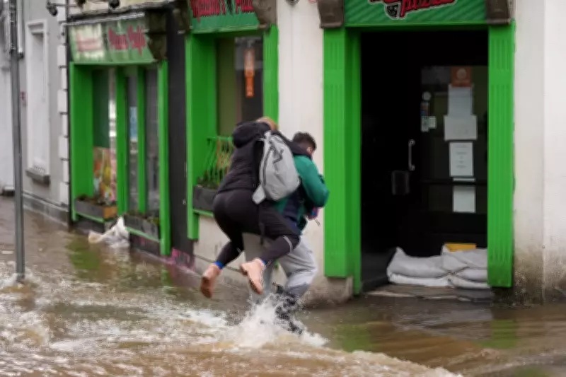
Most of the island of Ireland is currently under a series of weather warnings as forecasters have issued urgent alerts about a widespread and significant risk of flooding. A prolonged spell of heavy rainfall, which began overnight on Tuesday and is expected to continue throughout Wednesday, is falling onto already saturated ground and rivers that are close to bursting their banks.
Multiple Yellow Warnings Issued Across the Republic
In the Republic of Ireland, the national forecasting agency Met Eireann has issued several yellow-level warnings, informing the public of a flood risk in seventeen counties. However, the country's National Directorate for Fire and Emergency Management emphasised that flooding is a risk across the entire country, regardless of whether a specific yellow rain warning is in place for a particular area.
The agency stated clearly: "Whether or not a yellow rain warning is in place for a county, all areas will remain at risk of flooding." A yellow warning for rain applies to all of Leinster as well as Cavan, Monaghan, Cork, Tipperary, and Waterford, effective from 11pm on Tuesday until 11pm on Wednesday.

Met Eireann has highlighted that these regions face a serious risk of flooding, poor visibility, and difficult travelling conditions, compounded by already high river levels. The inclement weather will be further exacerbated by strong and gusty south-easterly winds in five of these counties.
Eastern Counties Face Dual Threats
Wexford, Wicklow, Meath, Louth, and Dublin are under an additional yellow warning for wind, with Met Eireann also cautioning against wave overtopping amid high tides until 1pm. This double warning applies specifically to areas in the east of the country, which have been severely affected by flooding in recent weeks.
The trend of wetter-than-average conditions in the east and south has continued persistently into February. Alarmingly, parts of the east have experienced three to four times the average rainfall amounts that would normally be expected during the first two weeks of February, significantly increasing the flood risk.
Snow and Sleet Add to the Hazard
A third yellow warning for rain applies to Donegal between 2am and 2pm on Wednesday, with Met Eireann warning that falls of sleet and snow are possible in this region. Some wintry precipitation is also possible over high ground in Wicklow, adding to the hazardous conditions.
In Northern Ireland, a yellow warning for rain and snow has been put in place for much of Wednesday. The Met Office provided detailed analysis: "An area of rain, falling as snow over some high ground, will move slowly east across much of Northern Ireland during Wednesday, before tending to ease later in the day."
The Met Office further explained: "This will be accompanied by strong south-easterly winds which may gust 45-55 mph in places, particularly during the morning. Rainfall totals of 10-15 mm fairly widely, with 20-30 mm in some southern and western areas. Whilst many places will see little if any lying snow, there is potential for several centimetres to accumulate on higher ground, chiefly above 250 metres, with the main focus being over the Sperrins during the morning."
Residents across the island are urged to exercise extreme caution, avoid unnecessary travel, and stay informed about local updates as the severe weather conditions unfold.


