
Britain is set to endure yet more flooding this week as heavy downpours and bouts of snow are forecast to batter the country. Much of England will face a cold start on Wednesday, with wintry conditions continuing to grip the UK and temperatures hovering just above freezing.
Widespread Rainfall and Snow Alerts
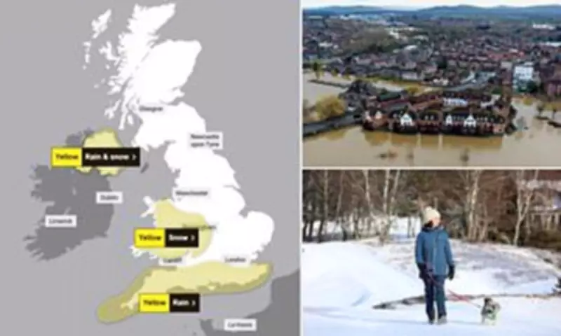
Torrential rain is expected this morning, particularly along the south coast. The Met Office has indicated that areas including Dartmoor and Devon could see as much as 50mm of rainfall. Other regions in the south may experience up to 30mm, while more widespread rainfall of 10-20mm is predicted across the country.
A yellow weather warning for heavy rain is currently in force for an area stretching from Cornwall to Kent, remaining active until 8am on Thursday. Simultaneously, a separate yellow warning for snow in the West Midlands and Wales will run from 4pm on Wednesday until 6am on Thursday.

Potential Disruption and Travel Impacts
The Met Office has warned that the combination of snow and strong winds could lead to significant disruption. There is a small chance that flights and train services may be cancelled, with vehicles potentially becoming stranded on roads. In Northern Ireland, outbreaks of rain, hill snow, and strong gusts of wind reaching 50-55mph are expected to cause further disruption, with a yellow warning in place until 8pm on Wednesday.
Senior Met Office meteorologist Craig Snell described Wednesday morning as likely to be "a very wet and windy morning" for many, though northern England may see a drier day. He noted, "By the time we get into the late part of the day on Thursday, the winds should be clearing away, and Thursday will just be a slow improvement day."
Cold Health Alert Issued
Officials have issued a 72-hour cold health alert as temperatures plummeted across the UK overnight. The UK Health Security Agency's yellow cold health alert came into force last night and covers parts of England until 6pm on Friday. This alert spans the East and West Midlands, North East, North West, South West, East of England, and Yorkshire and The Humber.
The agency has stated that the cold weather is likely to increase healthcare service usage by vulnerable individuals and poses a greater risk to life for these groups. This comes after many Britons have already experienced weeks of persistent wet weather, with some areas suffering over 40 consecutive days of rain.
Environmental Concerns and Flooding Risks
The Environment Agency has urged the public to remain "vigilant" regarding the ongoing threat of flooding. Recent weeks have seen around 340 properties flooded, with some regions recording their wettest January since records began. Northern Ireland and the southwest of England experienced their wettest January on record, receiving 170 per cent of their normal rainfall.
This excessive rainfall has left some rivers at record levels and increased the risk of groundwater flooding from saturated soil. Looking ahead, meteorologist Craig Snell offered a glimmer of hope, saying, "It's all change after that, by the weekend it will be feeling much, much milder with temperatures reaching the low-to-mid teens, if we see some sunshine. There will be further spells of wind and rain but most of us will certainly see an uplift of temperatures as we go into the weekend."


