
Triple Storm System Set to Blanket UK with Heavy Snow
Advanced meteorological modelling indicates that a formidable sequence of three winter storms is poised to strike the United Kingdom next month, with forecasts suggesting that a staggering 90% of the nation could be buried under significant snowfall. The Global Forecast System (GFS) weather model reveals that these consecutive blizzards may deposit up to 20 inches (52cm) of snow in some regions, commencing from February 11 and persisting through a four-day period of intense wintry weather.
Detailed Timeline of the Impending Snowfall
The initial flurries are projected to begin on February 11, with snow expected to fall across Wales, northern England, and Scotland by 3pm. Major urban centres including Manchester and Glasgow are likely to see the first accumulations as the system develops and begins its spread across the country.
By the early hours of February 12, around 6am, the focus shifts to southern England. The modelling suggests that heavy snow could impact cities such as London and Bristol, while Scotland may also experience further snowfall during this period. This represents a significant escalation in the weather event, bringing disruptive conditions to densely populated areas.

Second and Third Waves Intensify the Crisis
A second, more intense weather front is then forecast to hit the UK on February 13. This system is expected to bring the most severe initial snowfall to Northern Ireland and Wales from approximately 3am, before extending its reach to encompass London, Birmingham, Manchester, Liverpool, Cardiff, and Glasgow. As the day progresses, the snow is predicted to move eastward, with the most intense flurries targeting the Midlands and south-east by 9am, once again placing the capital in the path of substantial wintry showers.
The situation is set to reach a peak with a third major blizzard on February 14. This final storm is projected to sweep across the entire UK, with significant impacts expected in London around 3pm. By the conclusion of this prolonged weather event at 9pm on February 14, snow coverage maps indicate that almost every part of the country will have experienced some snowfall, with only isolated areas in south-west England and parts of Wales potentially escaping settled snow on the ground.
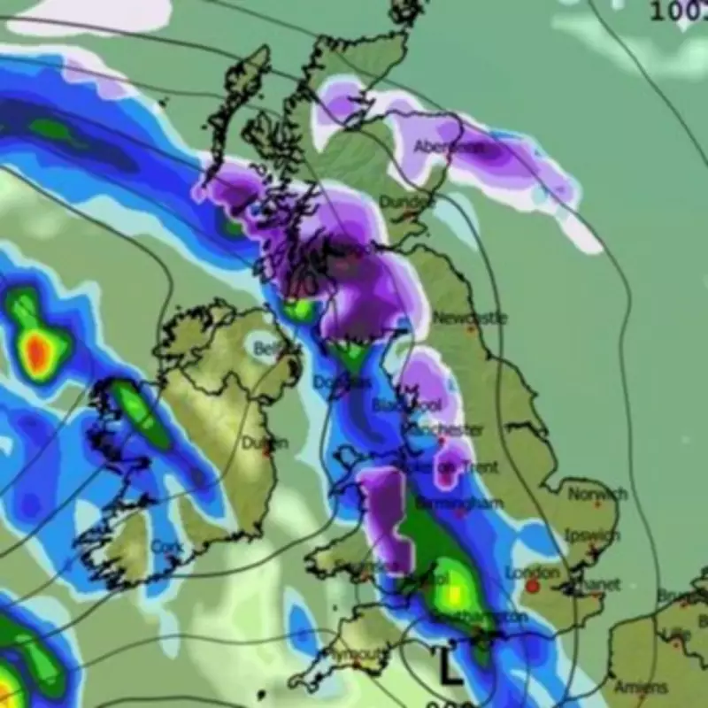
Projected Snow Depth Accumulations Across the UK
Snow depth charts provide a stark illustration of the potential impacts, with the most severe accumulations forecast for the Scottish Highlands, where up to 52cm (20 inches) could settle. Other regions are also braced for considerable snowfall:
- North-west England: Potential accumulations of 21cm (eight inches).
- Central England: Possibly 13cm (five inches).
- Wales: Parts could see 10cm (four inches).
- Northern Ireland: An expected 3cm (one inch).
Met Office Forecast Aligns with Severe Weather Warnings
The Met Office's own forecast for the period from February 5 to 14 corroborates the potential for disruptive winter weather. It notes that frontal systems over the Atlantic, guided by a south-shifted jet stream, are likely to approach the UK but may stall as they encounter a blocking area of high pressure to the north and north-east. This meteorological setup could result in further spells of rain, with a heightened risk of flooding in already sensitive areas.
As these rain bands move northwards, they are expected to encounter colder air, increasing the likelihood of snow on high ground in northern England and Scotland. The Met Office further anticipates a subtle southward shift of low-pressure areas during the second week of February, which may allow colder air to spread across at least northern parts of the UK, bringing an increased risk of wintry hazards for a time.

Looking ahead to the remainder of February, confidence in the forecast decreases, but the persistence of a south-shifted jet stream is likely to continue steering areas of low pressure towards and south of the UK. This pattern is expected to bring further spells of wet and windy weather, with rain most frequent in the south, west, and eastern Scotland. Some hill snow remains possible as this wet weather interacts with colder air across northern regions, with temperatures forecast to be close to average in the south-west but a little below average in the north-east.
The convergence of data from advanced modelling and the Met Office's own analysis paints a concerning picture for early to mid-February, urging residents across the UK to prepare for a period of significant winter disruption.


