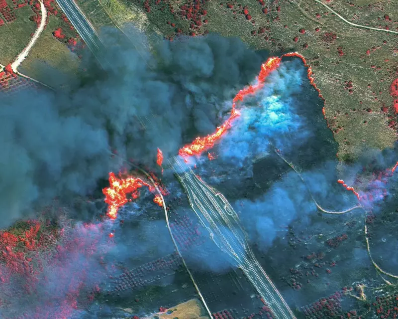
New satellite imagery has captured the terrifying extent of wildfires raging across Europe, with massive smoke plumes visible from space as the continent battles another extreme heatwave.
A Continent Ablaze
The images show multiple active fire fronts across southern Europe, with particularly intense blazes in Portugal, Spain and Greece. The thick smoke blankets stretch hundreds of kilometres across the Mediterranean region.
Climate Crisis Intensifies
Experts warn these devastating fires are becoming more frequent and intense due to climate change. "What we're seeing is unprecedented fire behaviour," said Dr. Elena Petrov from the European Climate Research Institute. "The combination of extreme heat, drought conditions and changing wind patterns is creating perfect conditions for mega-fires."

Emergency Response
Firefighters across affected countries are working around the clock, with several nations requesting international assistance. The EU's emergency response coordination centre has deployed additional planes and personnel to help battle the blazes.
Key Affected Areas:
- Portugal's Algarve region facing evacuations
- Spanish Catalonia battling multiple fronts
- Greek islands on high alert
- Southern Italy reporting new outbreaks
The satellite images provide a sobering perspective on the scale of destruction, with some smoke plumes reaching as high as 5km into the atmosphere.