
Spectacular yet terrifying satellite footage has revealed Hurricane Melissa's rapid transformation into a major weather system currently wreaking havoc across the Caribbean Sea. The newly released visual evidence shows the storm's dramatic intensification as it moves through vulnerable island territories.
A Storm Gathering Strength
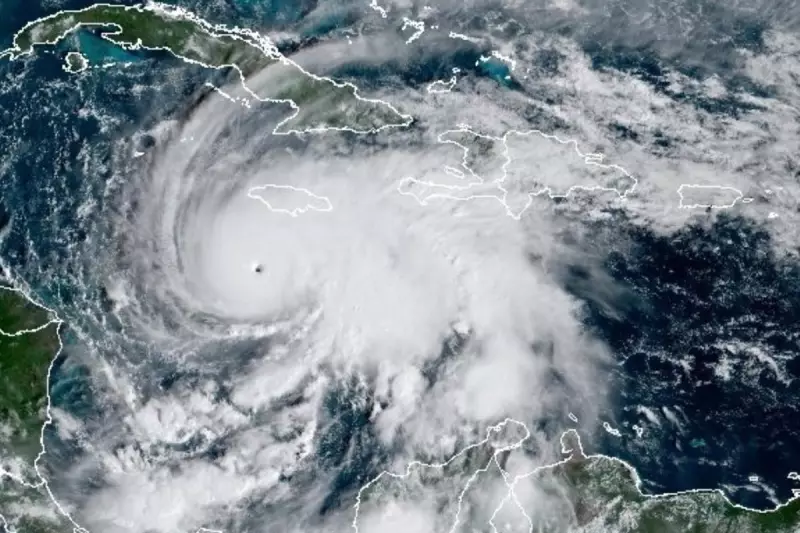
Meteorologists are closely monitoring Hurricane Melissa's progression as satellite technology captures every development of this formidable weather phenomenon. The high-resolution imagery clearly displays the storm's well-defined eye and powerful spiral bands, indicating significant strengthening in recent hours.
Weather experts have expressed particular concern about Melissa's organisation and structure, which suggests the potential for further intensification as it continues its path through warm Caribbean waters.

Regional Impacts and Warnings
Several Caribbean nations have already issued severe weather warnings as Melissa approaches. Emergency services across the region are on high alert, preparing for potential flooding, destructive winds, and dangerous storm surges that could threaten coastal communities.
Residents in vulnerable areas are being urged to:
- Monitor official weather updates continuously
- Prepare emergency evacuation kits
- Secure properties against potential damage
- Heed all evacuation orders from local authorities
Tracking the Hurricane's Path
The satellite monitoring provides crucial data for predicting Melissa's trajectory and potential landfall. Current models suggest the hurricane will continue northwestward, though meteorologists emphasise that tropical systems can be notoriously unpredictable.
Advanced weather tracking technology has become increasingly vital for early warning systems, giving communities precious additional hours to prepare for approaching severe weather events.
As climate scientists continue to study the relationship between warming oceans and hurricane intensity, storms like Melissa provide valuable, if concerning, data about evolving weather patterns in the Atlantic basin.


