
Tropical Storm Erin has rapidly intensified into Hurricane Erin, sparking concerns along the US East Coast as forecasters track its unpredictable path using spaghetti models. The storm, currently churning in the Atlantic, could bring heavy rains, strong winds, and coastal flooding to affected regions.
Uncertain Trajectory Sparks Warnings
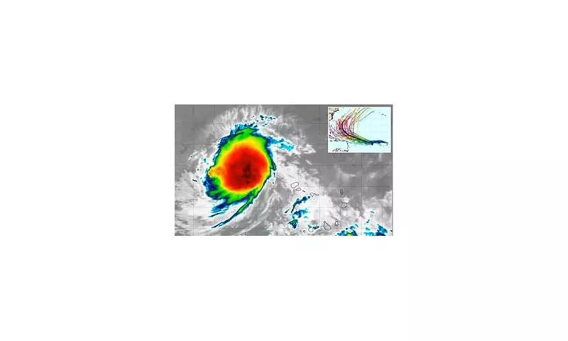
Meteorologists are closely monitoring Hurricane Erin's development, with multiple spaghetti models suggesting a wide range of possible tracks. Some projections indicate a potential landfall along the southeastern US, while others show the storm veering out to sea.
What Are Spaghetti Models?
Spaghetti models, used by weather experts, display various forecast tracks for tropical storms. The more clustered the lines, the higher the confidence in the predicted path. Currently, Erin's models show significant divergence, indicating high uncertainty.

Potential Impacts
If Erin makes landfall, coastal communities could face:
- Dangerous storm surges
- Flash flooding from heavy rainfall
- Power outages due to strong winds
- Beach erosion and coastal damage
Residents in potentially affected areas are advised to monitor updates and prepare emergency kits.
Historical Context
This isn't the first Hurricane Erin to threaten the US. A previous storm with the same name in 2001 caused significant damage in Florida before moving up the East Coast. Weather experts note that climate change may be contributing to more frequent and intense Atlantic hurricanes.
As Hurricane Erin continues to develop, officials urge caution and preparedness. The next 48 hours will be critical in determining the storm's ultimate path and potential impacts on populated areas.


