Britain is bracing for a significant wintry onslaught, with fresh weather maps indicating up to nine inches of snow could paralyse parts of the country next week. The most severe conditions are expected to strike on Wednesday, December 10, 2025, targeting several northern regions.
Five Counties Face Heaviest Snowfall
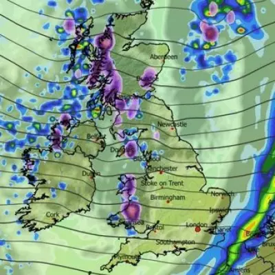
According to the latest data from WXCharts, which utilises MetDesk information, a major snow event is on the cards. The hardest-hit areas will be five Scottish counties, where snow depth is projected to reach between 16cm and 23cm (6 to 9 inches) by 6am on December 10.
The counties facing the most disruptive conditions are:
- The Highlands
- Argyll and Bute
- Perth and Kinross
- Stirling
- West Aberdeenshire
Further south, parts of Cumbria, Northumberland, and North Yorkshire may see a lighter dusting of snow, but the main focus remains on Scotland.
Sub-Zero Temperatures Accompany Snow
The snowfall will be accompanied by a bitter chill. WX Charts predict temperatures across the UK will be in the single digits by 6pm on Wednesday. For England, Wales, and Northern Ireland, this means a range of 2C to 8C. In Scotland, however, the mercury is forecast to plunge to between -1C and -3C, ensuring any snow that falls will settle and potentially cause travel chaos.
The Met Office's own long-range forecast for the period December 5 to 14 suggests any snowfall is likely to be concentrated over higher ground. It indicates a continuation of unsettled conditions, with rain and drizzle initially, followed by potential fog. The forecast warns of a band of "locally heavy rain" moving east later on Friday, December 5, which could turn to snow over higher elevations as colder air follows.
Immediate Weather Warnings in Force
Before the snow arrives, the country is dealing with a barrage of wind and rain. The Met Office has issued several severe weather warnings for Monday, December 1. Most notably, an amber "danger to life" rain alert is in place for central and south Wales for 24 hours from midnight.
Multiple yellow warnings for rain also cover vast swathes of the UK, including the East Midlands, North West England, South West Scotland, Yorkshire and Humber, London, and the South East. These warnings highlight risks of flooding and transport disruption.
Looking ahead, the national weather service expects clearer skies with scattered showers from Tuesday to Thursday, before "more persistent rain" moves eastwards on Thursday, bringing breezy conditions. This sets the stage for the colder plunge and potential snow event forecast for the following week. Residents in the affected areas are advised to monitor forecasts closely and prepare for possible travel disruption.


