
Advanced meteorological modelling has revealed alarming projections for the United Kingdom, with weather maps indicating the potential for a widespread and intense 36-hour snowstorm commencing on February 3. This significant weather event could follow closely on the heels of Storm Chandra, threatening to deposit staggering accumulations of up to 28 inches (70 centimetres) of snow in certain regions, transforming the landscape into a winter wonderland fraught with travel disruptions and hazards.
Timeline and Geographic Spread of the Impending Blizzard
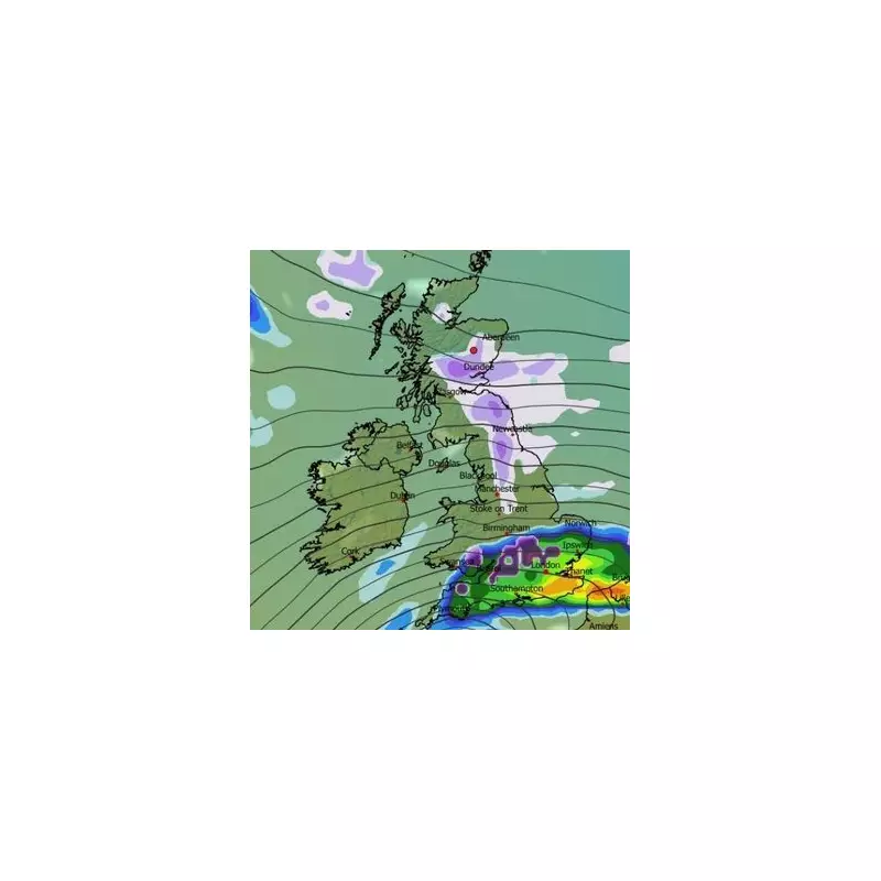
According to detailed analysis from the ECMWF weather model, the initial phase of this major snow event is forecast to begin around midday on February 3. While lighter flurries are anticipated across parts of Scotland, northern England, the Pennines, the Yorkshire Dales, and the Peak District, a more potent weather front advancing from the south poses a greater threat. This system is predicted to bring heavy snow combined with rainfall to southern regions and Wales, creating potentially treacherous conditions.
Major Urban Centres in the Firing Line
The weather maps suggest numerous major cities could experience significant snowfall during this event. Urban areas including London, Bristol, Birmingham, Nottingham, Leicester, Derby, Norwich, Cardiff, and Manchester are all identified as being within the potential impact zone. Furthermore, the entirety of Yorkshire is expected to receive snow, indicating a broad geographic reach for this winter storm.

By 3pm on February 3, modelling indicates a substantial band of snow will extend across Wales, England, and parts of Scotland. The most intense flurries during this period are likely to concentrate over East Anglia, Cambridgeshire, and the East Midlands. As the day progresses, the heaviest snow is tracked moving westward, with midnight maps showing an intense band stretching from South Wales right across the Midlands region.
Accumulation Projections and Storm Evolution
Snow depth charts paint a concerning picture of potential accumulations. The Scottish Highlands could bear the brunt of this system, with projections suggesting a remarkable 70 centimetres (28 inches) of settled snow. Northern England might see accumulations reaching 18 centimetres (seven inches), while Wales could receive up to 9 centimetres (3.5 inches). The Midlands may experience around 5 centimetres (two inches) of snowfall.
Continuation into February 4
The storm is expected to persist into February 4, with most snow activity becoming concentrated over Scotland. This will add to pre-existing accumulations across northern hills, potentially creating dangerous avalanche conditions in mountainous areas. By 9pm on February 4, weather models suggest most of the UK could be blanketed in snow, with only some parts of Northern Ireland and limited areas in the south and south-east of England escaping settled coverage on the ground.
Meteorological Context and Official Forecasts
The Met Office has also indicated the possibility of snowfall at the beginning of February, corroborating the broader timeline suggested by independent weather models. In its forecast for January 31 to February 9, the national weather agency notes that weather systems from the Atlantic will continue to attempt pushing eastward but may stall near the UK as they encounter high pressure to the north and northeast.
"As a result, further spells of rain or showers as well as strong winds are expected at times," states the Met Office forecast. "Rain may be heavy and persistent, especially in the south and west. Whilst mild conditions are expected to encroach into the south and southwest at times, cold air is likely to be positioned to the northeast, bringing wintry showers at times. Where fronts from the southwest do reach the cold air towards the northeast, there is the risk of some snow, most likely across hills, but perhaps extending to lower areas at times."
This forecast alignment between advanced modelling and official meteorological agencies underscores the seriousness of the potential weather event facing the nation in early February. Residents across affected regions are advised to monitor forecasts closely and prepare for possible travel disruptions, school closures, and the need for emergency supplies during this predicted 36-hour winter onslaught.


