
Twin Blizzards Set to Bury Britain in 48-Hour Snow Bomb
Advanced weather modelling maps have revealed that two powerful blizzards could bury most of Britain under significant snowfall within a dramatic 48-hour weather blast next month. The latest data suggests some regions could see accumulations of up to 14 inches (36cm) as wintry conditions sweep across the nation.
First Blizzard Strikes on February 13
The Global Forecast System (GFS) weather model indicates the first snow event will move across the UK during the morning of February 13, with flurries expected to affect Northern Ireland, Wales, central and northern England, and Scotland. Major urban centres including Birmingham, Manchester, Liverpool, Belfast, Edinburgh, and Glasgow could all face disruptive snowfall, with the possibility of flurries reaching as far south as London.
By midday on February 13, weather maps suggest the most intense snowfall will concentrate in eastern and northern regions. East Anglia and Yorkshire appear particularly vulnerable to being buried under accumulating snow, while Scotland continues to experience further flurries throughout this period. Heavy snowfall is projected to persist across affected areas for the remainder of the day.

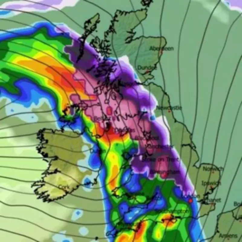
Second Blizzard Follows on February 15
A second, potentially more intense blizzard is tracked to hit Britain on February 15, beginning with Northern Ireland facing the heaviest initial snowfall. The Midlands and north-west England could also encounter significant snow during the early hours.
Around 3am on February 15, the GFS model shows intense flurries stretching from East Anglia across central and northern England all the way to Northern Ireland. The snow is then expected to continue moving northwards, engulfing Scotland by approximately 6am, creating widespread disruption across multiple regions simultaneously.
Snow Coverage and Depth Predictions
Snow coverage maps reveal the extensive nature of this impending wintry weather blast, with the majority of Britain and Northern Ireland expected to see settled snow on the ground. Data indicates that by 3pm on February 13, only southern parts of England might escape without any snow cover.
Snow depth charts present particularly concerning figures for certain regions. The Scottish Highlands could see accumulations reaching 36cm (14 inches), while parts of northern England might experience up to 11cm (four inches) of settled snow. These substantial depths have the potential to cause significant travel disruption and infrastructure challenges.
Official Weather Service Perspectives
The Met Office has acknowledged the potential for significant snowfall next month in its forecast for February 4 to 13. The national weather service states that frontal systems approaching the UK could bring spells of rain that may turn to snow as they encounter colder air, particularly over high ground in northern England and Scotland.
Their forecast notes: "A subtle shift southwards of these areas of low pressure is anticipated during the second week of February, which may allow a greater chance of colder air to spread across northern UK at least, bringing an increased risk of wintry hazards for a time."
However, BBC Weather presents a somewhat more cautious outlook for February 9 to 15, suggesting that while colder conditions are expected with temperatures dropping below average across the UK, there is currently no sign of any major snow event. Their forecast indicates wintry showers are likely over higher ground and possibly down to lower levels in northern regions, but widespread significant snowfall appears less certain according to their modelling.
The BBC forecast states: "These will turn wintry over higher ground, and down to lower levels in some northern regions. However, at the moment there is no sign of any major snow event. Drier and calmer interludes will lead to sharp overnight frosts and risks of fog."

This divergence between different forecasting models highlights the inherent uncertainty in long-range weather prediction, particularly for complex winter weather systems that depend on precise temperature gradients and atmospheric conditions.
Residents across Britain are advised to monitor official weather warnings closely as February approaches, with particular attention to updates from the Met Office regarding potential wintry hazards and travel disruption. The possibility of twin blizzards within a 48-hour period represents a significant weather event that could impact transportation, infrastructure, and daily life across multiple regions of the country.


