
Fresh Weather Chaos as Storm Chandra Hits UK
Families across Britain who were still clearing up after the weekend's Storm Ingrid have been warned to brace for further disruption today as Storm Chandra brings torrential rain, snow and powerful winds to already saturated regions.
Widespread Warnings and Flood Alerts
The Met Office has issued ten yellow or amber weather warnings covering substantial portions of the country, forecasting up to 3.1 inches of rain, 8 inches of snow on higher ground, and potentially damaging gusts reaching 80mph. Some 120 areas have been placed on flood watch as the 35-hour storm system, which began impacting South-West England from yesterday afternoon, spreads across the nation.
Forecasters have warned that some communities could become completely "cut off" by flooded roads. This comes in the wake of Storm Ingrid, which caused significant damage including the partial washing away of Teignmouth's Grand Pier in Devon and prompted a police search for a missing kayaker on the River Exe.

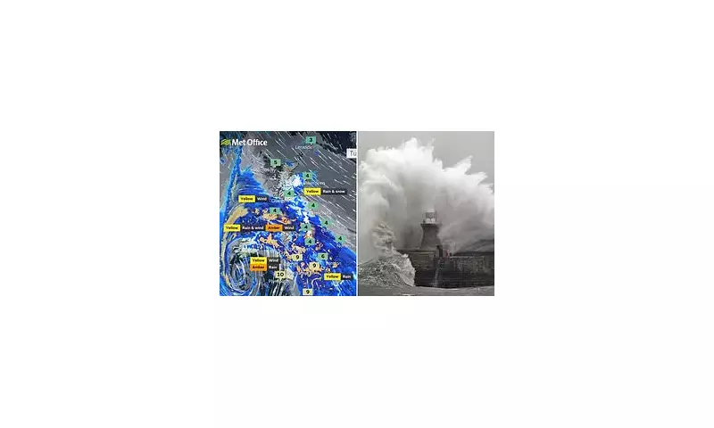
Regional Impacts and Hazard Details
The strongest winds are expected to batter the South-West and Wales, with Pembrokeshire and the Isles of Scilly potentially experiencing the most severe 80mph gusts. Meanwhile, snow is likely to accumulate on higher ground in the Pennines and Scottish mountains as a series of Atlantic weather systems drives wet and windy conditions across Britain.
An amber weather warning remains in effect on the east coast of Northern Ireland until 9pm today, with an additional yellow rain and wind warning covering the entire region for all of Tuesday. In Scotland, yellow warnings for snow have been implemented as some elevated areas could see up to 8 inches of accumulation.
Specific warnings include:
- An amber warning for rain covering south Devon, much of Dorset, southern Somerset and south-east Cornwall until 9am Tuesday
- Yellow warnings for wind covering Cornwall, southwestern Wales and parts of northern Devon from 5am to 4pm Tuesday
- Yellow warnings for rain and snow across the Pennines and southwest Scotland from midnight to 5pm Tuesday
- Yellow rain warnings for much of southeast England until midday Tuesday
Official Warnings and Safety Advice
The UK Health Security Agency has activated cold-health alerts for northern England until Friday, highlighting a "greater risk to life of vulnerable people" during this period of severe weather.
Chris Wilding, flood duty manager at the Environment Agency, stated: "Due to the arrival of Storm Chandra, significant surface water flooding impacts are probable today and tomorrow in the south west of England, and tomorrow there is a significant risk of river flooding impacts too. Environment Agency teams are out on the ground, taking action to reduce the impact of flooding and support those communities affected."
RAC spokesperson Nick Mullender issued stark advice to motorists: "Flooding is highly likely, making many roads dangerous. Our message to drivers is simple: do not drive through standing water unless you are completely certain the water is shallow enough and it's safe to do so. In these conditions, drivers need to slow down and stay alert. Wet roads can double stopping distances."
Continuing Unsettled Conditions
According to Met Office Chief Forecaster Steve Willington: "Unsettled conditions will continue through the week, with a combination of rain, brisk winds and some further hill snow, particularly in northern areas where colder air remains in place."
The Met Office has also warned of potential "large waves" in some coastal areas covered by the warnings, with risks including "debris being blown around" and "tiles coming off roofs." In Dorset and Devon, where amber rain warnings are active, there is additional concern about possible coastal landslides.
Transport Disruption and Infrastructure Damage
In the southwest of England, the public has been warned to expect cancellations to train and bus services, with flooding potentially isolating some communities. A sea wall protecting the railway line at Dawlish partially collapsed during Storm Ingrid, causing train services to be suspended between Exeter St Davids and Plymouth on Saturday.

Further north, in South Shields, a sea wall on the South Pier suffered partial collapse during Storm Ingrid - adding to damage sustained in 2023 when Storm Babet ripped off the pier's lighthouse.
Preparation and Recovery
The Met Office has advised residents in at-risk areas to prepare emergency kits containing insurance documents, contact numbers, torches with spare batteries, first aid supplies, prescription medicines, waterproof clothing, bottled water and snacks.
Storm Chandra represents the next named storm in the western Europe storm naming group list shared between the UK, Ireland and Netherlands, continuing what has been an exceptionally turbulent winter weather period for Britain.


