
Detailed weather forecasting maps have revealed the potential for a major 'Beast from the East' snowstorm to sweep across the United Kingdom, with projections indicating that up to 90 percent of the country could be buried under snow within days.
Imminent Snowfall Threat for Major Urban Centres
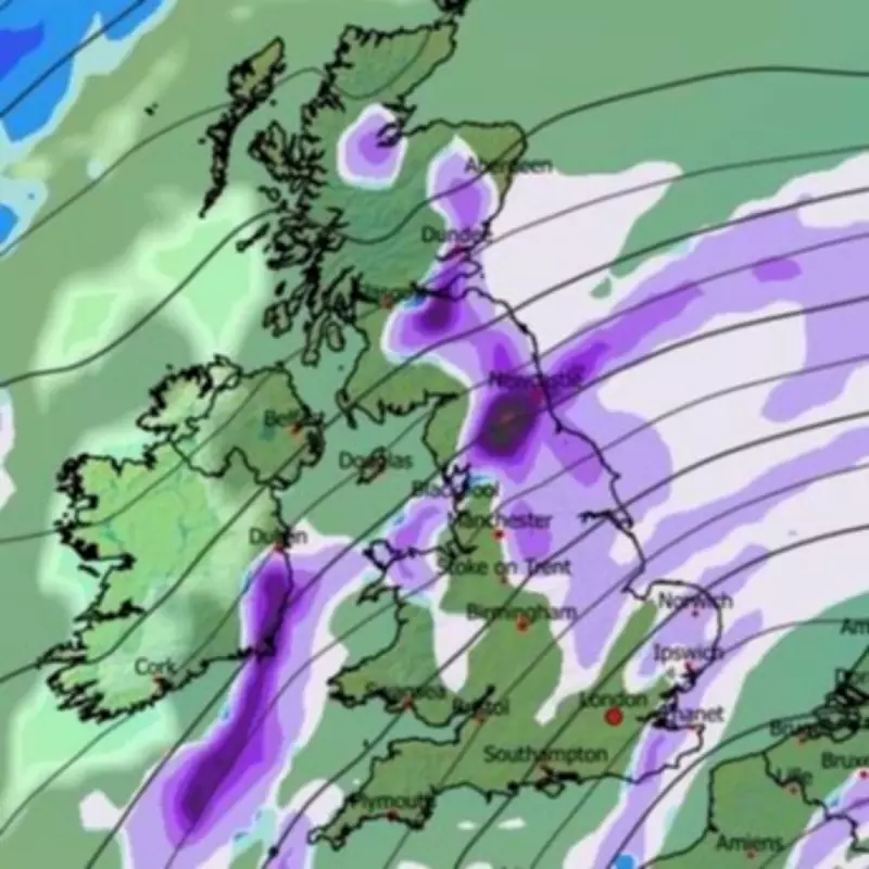
According to the latest data from the GFS weather model, a substantial blizzard is predicted to form to the east of Britain in the early hours of Sunday, February 9. This system is forecast to move rapidly westward, engulfing vast swathes of the nation by 9am that morning.
The initial snowfall is expected to impact Scotland, northern England, eastern England, and North Wales first. However, meteorological projections suggest the storm will persist for many hours, continuing its advance across the country.

Southern Regions Brace for Impact
By 9pm on February 9, the snow is anticipated to reach southern cities including London and Bristol. Further accumulations are forecast for the East Midlands, East Anglia, and Wales throughout the evening period.
Data analysis indicates that the most intense flurries will likely occur in Scotland and the north-east of England. Urban centres such as Newcastle, Edinburgh, and Glasgow should prepare for significant snowfall.
Prolonged Wintry Conditions Expected
The snowfall is projected to continue throughout February 10, with the south-east of England becoming the focal point. London may experience prolonged wintry showers during this period.
By the conclusion of this cold weather event, approximately 90 percent of the UK is expected to have at least some snow settled on the ground. Coverage maps for 6am on February 10 show almost the entire country coloured in purple, indicating widespread snow cover.
Substantial Accumulations Predicted
The greatest snow depths are forecast for elevated areas in North Wales, northern England, and Scotland. Snow depth charts suggest potential accumulations of 39 centimetres (15 inches) in the North Pennines and 33 centimetres (13 inches) in the Scottish Highlands.
Fortunately for residents in central and southern England, including major cities like London and Birmingham, accumulations are not expected to exceed 1 centimetre in most locations.
Meteorological Authority Issues Warning
The Met Office has acknowledged an "increasing" risk of snow as February progresses. Their official forecast for February 2 to 11 states: "This period will start off in a similar vein to current conditions. This means largely unsettled weather is expected, with showers or longer spells of rain for many places and occasionally rather windy."
The forecast continues: "Some hill snow is likely in the north too. Temperatures will be close to average for most, but perhaps rather cold in the far northeast. A subtle change is now looking likely during the second half of this period, as the winds look like backing off to more of an easterly or northeasterly direction."
"It is likely to remain largely unsettled, especially towards the south, but it is likely to become colder with an increasing risk of snow, more particularly in the north. An often brisk wind will accentuate the colder feel too."
Extended Forecast Remains Cautious
Looking further ahead, the Met Office forecast for the remainder of February adds: "Whilst incursions of wet, windy and milder weather are favoured at times in the south and later the west, colder conditions further north will bring an increased risk of wintry hazards, especially where any precipitation from the southwest interacts with the cold air. The colder conditions may affect all parts at times, more especially early in this period."
This developing weather situation requires close monitoring as the predicted dates approach, with the potential for significant disruption to travel and daily activities across much of the United Kingdom.


