
Emergency services are leading a major clean-up operation after "unprecedented" flash flooding devastated parts of Victoria's surf coast, washing cars into the ocean and displacing hundreds of holidaymakers. The violent weather event, which dumped 180mm of rain in just six hours around Lorne and Wye River on Thursday, caused rivers to burst their banks, inundating campgrounds and destroying dozens of vehicles.
An Unprecedented Deluge and its Immediate Aftermath
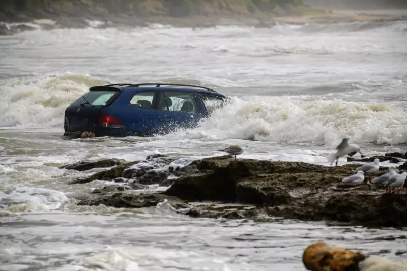
The intense rainfall, described by Victoria's State Control Centre as an unprecedented weather event, triggered severe flash flooding of the Wye, Kennett and Cumberland rivers. Approximately 400 people, including many staying at a local caravan park, were forced to flee to higher ground. Photographs from the scene show the powerful aftermath, with waves crashing into vehicles that had been swept out to sea and personal belongings scattered across mud-covered beaches.
Colac mayor Jason Schram publicly questioned the forewarning provided, asking how such an extreme rainfall event could not have been predicted. "It's pretty messy, with mud, debris and, of course, everyone's personal belongings, caravans, camping gear," he told reporters, highlighting the scale of the destruction for those caught in the sudden deluge.

Authorities Defend Emergency Response Timing
Despite the criticism, emergency management authorities have robustly defended their actions. Dharni Giri, a spokesperson for the State Control Centre, stated that warnings were "not issued late." She revealed that more than 10,000 people in the area received emergency text alerts advising them to move to higher ground.
"Our response was pretty incredible when you think about how quickly it happened and how quickly we were able to mobilise SES crews, the local CFA brigade, and other emergency partners," Giri said. She credited this rapid mobilisation for the fact that no deaths or serious injuries were reported despite the severity of the flooding.
The Bureau of Meteorology explained its warning process, noting that a severe thunderstorm warning for heavy rainfall was first issued at 11:57am AEDT after 45mm fell in one hour at Mount Cowley. This was soon escalated to a warning for intense rainfall as observations continued to climb rapidly.
Further Severe Weather Threatens NSW South Coast
As Victoria begins its recovery, the focus shifts north. The Australian Bureau of Meteorology has issued further severe weather warnings for the coming days, predicting more flash flooding across southern New South Wales and Victoria. Senior meteorologist Angus Hines warned that the Illawarra and NSW south coast could see 150 to 200mm of rain between Thursday afternoon and Saturday night, leading to significant flash flooding, damaging winds, and travel disruption.
"It's going to be very rough on the coastline for boats and maybe even have an impact on flight and travel," Hines cautioned. The severe winds are also expected to hamper efforts to control the seven major bushfires still burning across Victoria, although cooler conditions have recently aided containment efforts.
Giri noted that a state of disaster remains in place until 8 February, with over 411,000 hectares already burnt. She urged communities to remain vigilant, with more hot weather forecast for next week, keeping fire risks elevated.
This extreme event occurs against a backdrop of a worsening climate crisis. A recent report from the Insurance Council of Australia warned that the country is becoming more vulnerable to unpredictable weather and natural disasters. The World Meteorological Organisation has confirmed that global temperatures continue to soar, with 2025 continuing a streak of extraordinary heat, averaging 1.48°C above pre-industrial levels.


