
A major weather emergency is unfolding across northern Australia as intense monsoon rains threaten to trigger severe flooding, isolate communities, and strand travellers. The Bureau of Meteorology has issued urgent warnings for the Northern Territory and Queensland, with a large, slow-moving weather system predicted to deliver a colossal drenching.
Monsoon Trough Brings Torrential Downpours
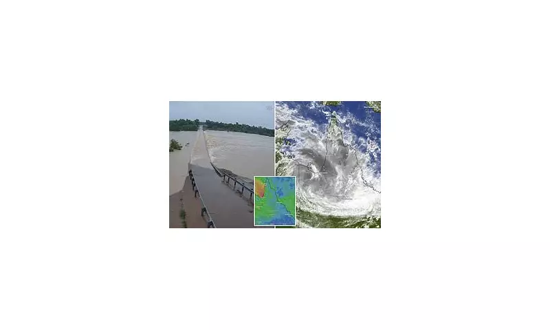
A significant monsoon trough, extending from the Top End deep into Queensland, is intensifying and is forecast to bring increasingly widespread rain and thunderstorms. The Bureau of Meteorology stated on Sunday that the heaviest rainfall will be concentrated in Queensland's Gulf Country, directly impacting areas around Mount Isa and Julia Creek.
Forecaster Jonathan How warned that for the tropical coast from Cairns to north of Townsville, peak six-hourly rainfall totals would escalate from Sunday night into Monday, potentially reaching between 120 to 200 millimetres. "Thunderstorms could deliver even higher rainfall totals, and we expect heavy rain to continue through Monday and possibly beyond," Mr How said.

Communities Brace for Isolation and Danger
The bureau has explicitly warned that the impending heavy rain and flooding pose a serious risk to life and property. Key concerns include widespread road closures and the isolation of remote outback communities. Authorities have identified Mount Isa, Cloncurry, Burketown and Normanton as being at particularly serious risk.
In response, sandbagging stations have been opened in the Mt Isa and Hinchinbrook areas, with locals strongly urged to take immediate precautions. The popular tourist destination of Hinchinbrook remains in the firing line, with Mayor Ramon Jayo indicating the worst is expected from Monday. He cautioned on social media that while river levels were currently low, the situation "may change rapidly" depending on where the heaviest rain settles.
Record Rainfall Already Recorded
The severe weather event is already in motion, with staggering rainfall totals recorded across the region. In a dramatic three-hour period to midday on Sunday, some areas were deluged:
- Gairloch, north of Ingham: 200mm
- Cardwell Gap, south of Tully: 217mm
- Ingham: 185mm since Saturday morning
- Paradise Lagoon near Mount Isa: 174mm
Mr How confirmed that rainfall totals would continue to climb as the system moves, with isolated areas potentially receiving up to 700mm. Residents in low-lying areas have been advised to protect their property, as drainage systems may be overwhelmed by the torrential downpours. The bureau's flood watch warnings remain active for the Barkly and Carpentaria catchments in North-Western Queensland and the North Tropical Coast.


