
Satellite Images Begin to Reveal Widespread Damage in Iran War
Satellite photographs are now being released that provide a stark visual account of the destruction wrought by the ongoing Iran war. The images, which have started to emerge publicly, show ships burning in an Iranian port and buildings reduced to rubble at military bases across the region.
Scarce Information and Delayed Release
Since the conflict began on February 28, information about the extent of damage across the Middle East has been extremely limited, particularly concerning closed military facilities. The newly available images come primarily from Planet Labs PBC, a San Francisco-based company that provides satellite imagery to media outlets including The Associated Press. Planet Labs has implemented a two-week delay on making its imagery public, citing concerns that the images could be exploited by adversarial actors.
Other firms have also published high-resolution satellite photographs, while organizations like the U.S. Geological Survey have released lower-resolution imagery that has proven valuable for analysis. The conflict has seen the United States and Israel striking numerous targets, including:
- Leadership figures
- Military bases
- Missile and air defense sites
- Positions of Iran's paramilitary Revolutionary Guard and its volunteer Basij force
Iran has responded with drone and missile attacks targeting Israel and nearby Gulf Arab nations.
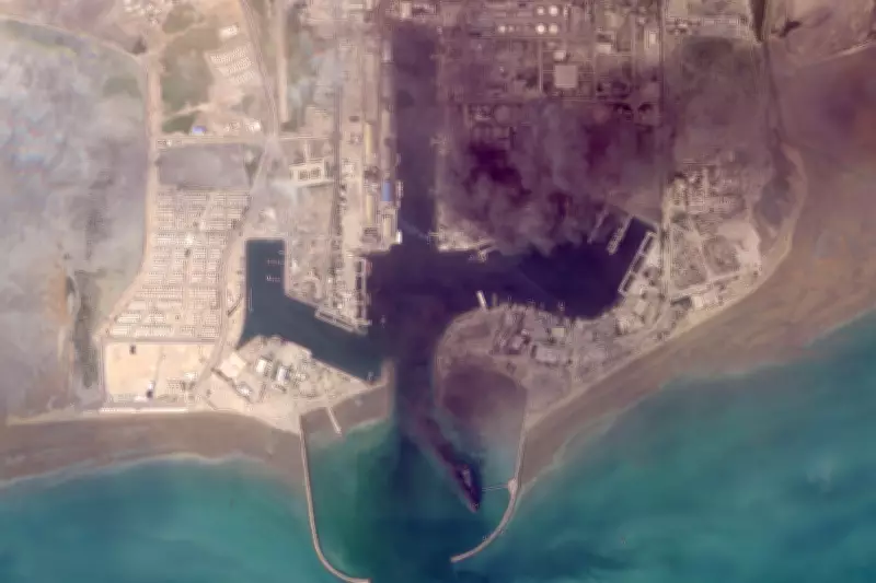
Dramatic Scenes at Bandar Abbas Port
Some of the most striking images from Planet Labs show the situation at Bandar Abbas, home to a major Iranian military port adjacent to the strategically vital Strait of Hormuz. Photographs taken on March 2 reveal multiple ships ablaze at the port facility. The U.S. military's Central Command has confirmed targeting Iran's naval assets, claiming to have sunk or damaged more than 100 Iranian vessels since the war began.
Significant Damage at U.S. Naval Headquarters
The island kingdom of Bahrain, which hosts the U.S. Navy's 5th Fleet headquarters, has experienced heavy Iranian fire targeting both military installations and oil facilities. A Planet Labs image from March 1 shows a major building at the base completely destroyed, along with two radomes—the geodesic domes that protect radar antennas—likely damaged by Iranian missile and drone attacks.
While the Navy has not provided a comprehensive assessment of the damage sustained at the base, Iran has repeatedly claimed successful attacks on the facility. Online videos have captured incoming fire targeting the Bahrain base. During the previous conflict in June, Iran destroyed a similar radome at Al Udeid Air Base in Qatar that was used for secure communications.
French Naval Base Impacted in Abu Dhabi
In Abu Dhabi, the capital of the United Arab Emirates, satellite images reveal damage at France's Camp de la Paix naval base. Images from March 3 show significant damage to two large hangar-style buildings at the facility. The base is located near Zayed Port and close to Abu Dhabi's Cultural District, which includes the Louvre Abu Dhabi and other major museums, some of which are still under construction.
Widespread Fires Detected Across Region
The U.S. Geological Survey's Landsat satellites have been instrumental in identifying major fires resulting from the conflict. Imagery from Monday showed a fire at Dubai International Airport, where an Iranian drone strike ignited a fuel tanker at the world's busiest airport for international travel, creating a plume of toxic black smoke.
Another fire was detected on Monday at Oman's southern port in Salalah, which came under attack from suspected Iranian drones on March 11. Tehran has denied launching these drones as part of its campaign against Gulf Arab states. The fire appears to have been burning continuously since the attack occurred.