The North East is expected to experience warm temperatures over the next few days, but will we get a heatwave? The Met Office has offered its predictions on this.
Weather Forecast Overview
Weather experts say the mercury will reach the high 20s quite widely, with the potential for 32°C to be reached in the south of England on Sunday and potentially even higher temperatures on Monday. Alongside the warmth, there will also be spells of rain, particularly across northern and western areas, and a slight chance of thunderstorms across southeastern England.
Newcastle Temperatures
In Newcastle, forecasts show highs of 24°C on Friday, followed by 22°C on Saturday and 21°C on Sunday. At the time of writing, Tuesday, June 23, was showing temperatures climbing to 25°C. ChronicleLive has all the latest weather news here.

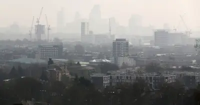
While some parts of the country, particularly the south, are set to get heatwave conditions, the North East may not quite meet the criteria. The Met Office says there will be a north-south divide with the weather.
Heatwave Definition
In the UK, a heatwave is officially defined as a location recording at least three consecutive days with daily maximum temperatures meeting or exceeding the heatwave temperature threshold. This threshold varies by county, reflecting the diverse climate across the UK.
Health Alerts
Outside of the North East, a yellow heat-health alert has been issued by the UK Health Security Agency, which means temperatures could lead to impacts on the health and wellbeing of some people. This covers the East Midlands, East of England, London and the southeast of England from Wednesday, June 17, and remains in place until Monday.
Current Weather Picture
The Met Office says it’s currently a mixed and unsettled picture across the UK, with outbreaks of rain affecting many areas on Wednesday and into Thursday. Some of this rain could be heavy, particularly across parts of the north and west, while elsewhere there will be a mix of cloud and brighter spells, with conditions remaining humid.
From the end of the week, a "marked north–south split develops". High pressure over mainland Europe will allow increasingly warm and humid air to build across southern and eastern areas, while lower pressure close to the northwest keeps conditions more changeable.
Temperature Forecast
Temperatures are expected to climb steadily, with southern parts of England approaching 30°C by Friday, depending on cloud cover, and becoming very warm more widely through the weekend. Some areas in the south and southeast of England are likely to see heatwave criteria met by Saturday and more widely on Sunday, with the potential for temperatures to reach the low 30s in the warmest locations.
- 32°C on Friday in East Anglia
- 28°C on Saturday as the warmest air temporarily shifts away from the UK
- 32°C in the south and southeast of England on Sunday
- Potential for 33°C in the same areas on Monday
Expert Comment
Deputy Chief Forecaster, Gregory Wolverson, said: “This week’s weather reflects a contrast we often see in summer, with more unsettled conditions passing to the northwest of the UK while heat builds in the south and east. As we move towards the weekend, we’ll see conditions become more widely settled and temperatures rise all round. Many parts of southern and eastern England are likely to see temperatures high enough to meet heatwave thresholds.”
“It’s important to note that while temperatures may be high, we might not all see the wall-to-wall sunshine and blue skies we experienced back in May because there is more cloud around. There is also a chance of thunderstorms developing in places, particularly later each day, which could bring heavy showers and localised impacts.”
Broader European Context
Looking more broadly, much of central and western Europe is also experiencing notable heat, with temperatures well above average in places. This is helping to feed warmer air towards the UK as conditions develop towards the weekend.
North East Weather Forecast
Wednesday Night
Extensive low cloud with some drizzle on western hills overnight. Elsewhere, drier with variable cloud and some clear spells, especially to the east of higher ground. Mild. Minimum temperature 11°C.

Thursday
Cloudy with spells of rain, locally heavy, moving erratically northeastwards across all parts during Thursday. Rain easing into the afternoon. Warm and muggy. Maximum temperature 21°C.
Outlook for Friday to Sunday
Changeable and often cloudy through this period, with some spells of rain or showers moving erratically eastwards. Perhaps drier with warm sunny spells into the weekend, with temperatures climbing.