
Temperature Plunge Across Scotland and Northern England
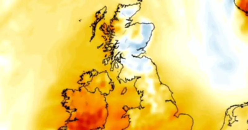
Weather maps from WXCHARTS.COM indicate that temperatures will fall below 10°C in multiple counties within days, just after the UK experienced a scorching heatwave. By 7am BST on Monday, July 13, large parts of Scotland and an area creeping into Northumberland, England, could see mercury drop to 9°C. A temperature anomaly map shows these regions blanketed in blue, indicating temperatures below the baseline average for July.
Full List of Areas Affected
Minimum temperatures are forecast to drop to 9°C across at least 14 Scottish unitary councils, including: Aberdeenshire, Aberdeen, Angus, Argyll and Bute, Perth and Kinross, Stirling, southern areas in the Highlands, Mid Lothian, East Lothian, East Ayrshire, South Lanarkshire, Dumfries and Galloway, and the Scottish Borders. Additionally, Northumberland in England could also see 9°C.
Warmer Conditions Elsewhere
Temperatures across England and Wales will be warmer around this time, ranging from around 10°C in the northernmost areas of England to high teens along the south coast. Minimum temperatures in Wales are set to range between 13°C and 18°C on the west coast, while Northern Ireland may see lows between 13°C and 16°C.
Heat Returns Later in the Day
Despite the morning chill, large stretches of the British Isles are blanketed in red on weather maps later in the day, indicating a return of high temperatures. By 7pm, Scotland's minimum temperatures range between 15°C and 21°C, England's from 17°C in the far north to 29°C in the southwest, Wales from 23°C to 28°C, and Northern Ireland from 20°C to 23°C.
Met Office Heatwave Update
In an update on Wednesday, the Met Office stated that temperatures are "expected to climb into the mid-30s across parts of the UK this week as hot, settled conditions continue, with many areas experiencing their third heatwave of the year." The UK Health Security Agency (UKHSA) has issued amber and yellow heat health alerts, "meaning significant impacts are likely across health and social care services due to the high temperatures."
The Met Office added: "High pressure remains the dominant feature through the rest of this week, bringing extensive sunshine, dry weather and temperatures widely above 30°C. The hottest conditions are expected on Thursday and Friday, when some locations in England could reach 35 or 36°C. While the heat will gradually ease across southern and eastern parts of the UK during the weekend and into next week, very warm weather is set to continue as the focus of the highest temperatures shifts towards the southwest."
Forecaster's Perspective
Tom Crabtree, Deputy Chief Forecaster at the Met Office, said: "Many people will understandably want to know how long the current heatwave is likely to last. While temperatures are expected to ease across southeast England through the weekend and into next week, it won't be a straightforward end to the warm weather. High pressure is expected to remain in charge through much of next week, but it will gradually migrate northwards. This means that an easterly wind will become established in the south, and the focus for the hottest conditions will migrate towards the southwest. As a result, some places that have seen the highest temperatures during recent weeks will begin to cool. It will however, remain very warm – especially in the southwest – and heatwave thresholds may continue to be met in places. The overall signal is for continued fine, dry and very warm weather at times for many parts of the UK into next week. There is however a chance of thunderstorms spreading into parts of the south and southwest."




