The Met Office has said there are signs a sudden stratospheric warming (SSW) is “developing” over the North Pole, a development it described as “exceptional” for this early in the season. The forecaster warned the stratospheric polar vortex is “currently being disturbed” and linked the disruption to the ongoing El Niño, which it said has exceeded previous records to become the strongest event in history.
What is happening above the Arctic
According to the Met Office, the stratospheric polar vortex is currently “unusually stretched”. The disturbance is associated with what is known as “wave two” activity, in which two large atmospheric waves push into the vortex from opposite directions. The forecaster said this wave two activity is considerably stronger than average for the time of year, and forecasts suggest the vortex will subsequently become increasingly displaced from the North Pole.
The presence of El Niño, which developed over the Pacific Ocean and helped fan a summer of record temperatures, is associated with an “increased risk” of cold snaps and an increased likelihood of an SSW, the Met Office said.
Potential effects on UK weather
The current disturbance is already producing warming in the stratosphere above the North Pole, and forecasts indicate temperatures are continuing to rise. Some experts believe the winds could “briefly reverse” in the coming days, potentially meeting the definition of a “major SSW”, according to the Met Office. Any reversal is expected to be fairly weak and brief, but its timing is viewed as significant, as such events typically happen later in the winter season.
The Met Office has said a major SSW does not automatically mean snow or severe cold weather for Britain. On its website, the forecaster said: “When an SSW occurs, its effects can sometimes propagate downwards into the troposphere over the following two to six weeks. This can weaken the Atlantic jet stream and increase the likelihood of blocking areas of high pressure developing.
“Where those areas of high-pressure form is crucial. High pressure over the UK could bring quieter, drier conditions with an increased likelihood of frost and fog. Blocking farther north could encourage easterly winds, while high pressure to the west could make northerly winds more likely. Historically, an SSW increases the chance of colder UK weather, but the outcome is far from guaranteed.”
Current outlook and long-range forecast
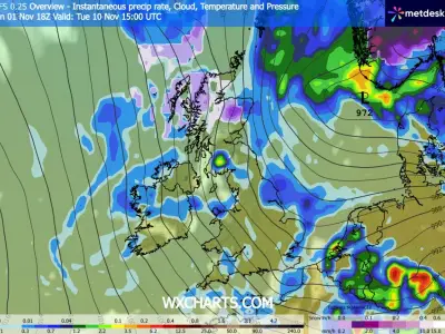
The Met Office said as it stands, there is no forecast for an “impending” cold snap in the UK. However, it confirmed meteorologists will be watching the development closely. Recent weather maps have shown Britain could be hit by a blast of wintry weather next week.
The Met Office’s long-range weather forecast, for November 10-19, states: “High pressure begins to migrate away to the east allowing frontal systems to progress into the UK from the southwest, although exactly how much progress into the UK this makes is uncertain. However there is a greater chance that at least the southern half of the UK will see a change to milder and wetter conditions, at least for a time, while the north is more likely to remain drier.
“Toward the end of next week we may start to see some colder conditions spread from the north. While the nature of this colder outbreak is very uncertain, it could bring some wintry showers to the northern UK briefly. Thereafter, a transition towards a westerly flow is likely, bringing changeable conditions with rain more likely focused towards the north west.”