
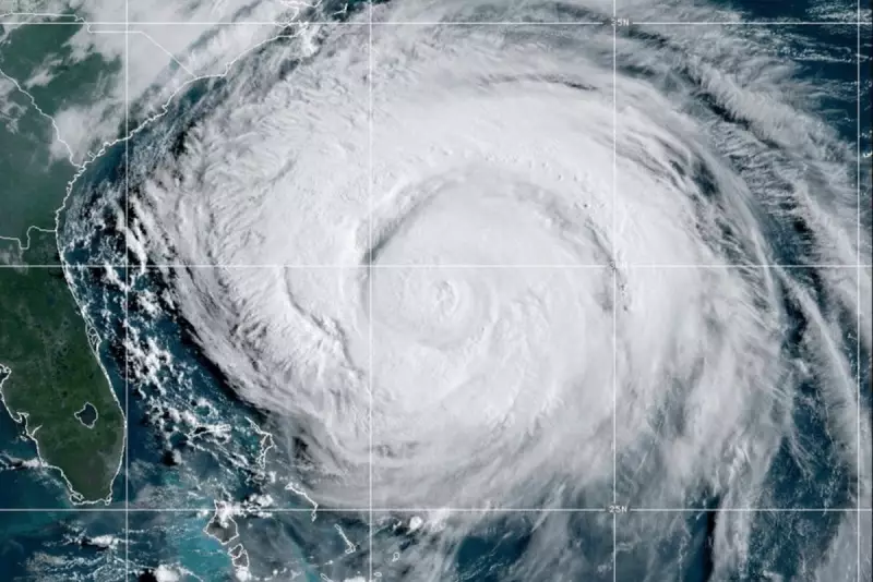
The Atlantic hurricane season has roared to life as Hurricane Erin undergoes rapid intensification, transforming into a formidable Category 3 major hurricane. The storm is now posing a severe and imminent threat to the United States' eastern seaboard, prompting urgent warnings from meteorologists and emergency officials.
The latest advisory from the National Hurricane Centre (NHC) places the storm's current position several hundred miles east of the Bahamas. It is packing sustained winds of a devastating 120 mph (193 km/h) and is forecast to maintain its strength as it continues on its north-westerly track.
Projected Path and Immediate Threats
Current modelling indicates Hurricane Erin is most likely to make a direct impact along the coastline of the Carolinas or Mid-Atlantic states by late Sunday or early Monday. However, officials are cautioning that a wider area, potentially stretching from Georgia to New England, should remain on high alert for significant effects.

The primary dangers associated with this powerful system are multifaceted and life-threatening:
- Catastrophic Storm Surge: A powerful wall of water is expected to be pushed ashore, capable of causing unprecedented flooding in coastal communities. The NHC warns this will be the greatest threat to life and property.
- Destructive Hurricane-Force Winds: Widespread structural damage, downed trees, and prolonged power outages are anticipated well inland from the point of landfall.
- Torrential Rainfall and Inland Flooding: The slow-moving nature of the storm could dump 8 to 12 inches of rain, with isolated areas receiving up to 15 inches, triggering flash floods hundreds of miles from the coast.
Coastal Regions Urged to Prepare
Residents across the entire eastern seaboard are being urged to finalise their hurricane preparedness plans immediately. State governors have already declared states of emergency, and mandatory evacuation orders are expected for low-lying and vulnerable areas in the coming hours.
"Now is the time to act," an NHC spokesperson emphasised. "If you are in the warning area, your window to prepare is closing rapidly. Secure your property, review your evacuation route, and heed all advice from local emergency management."
This developing story is being closely monitored. The Independent will provide continuous live updates on Hurricane Erin's path, intensity, and the latest official guidance as the situation evolves.


