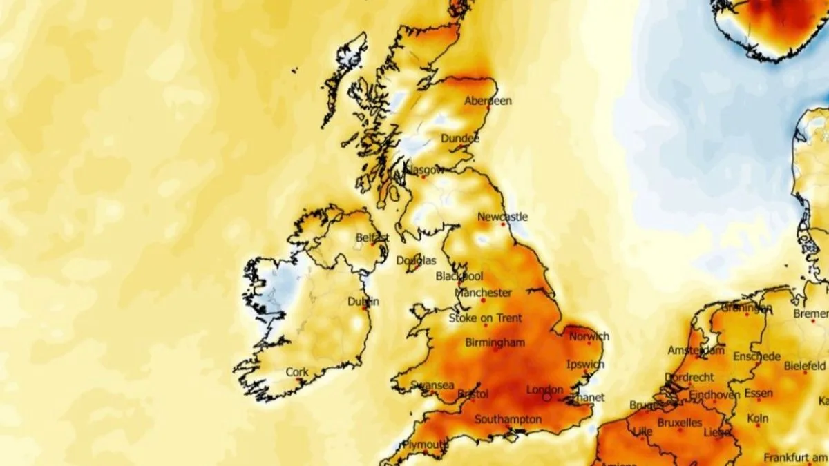
UK Weather Maps Forecast 22C Heat Surge Over Three Days Across 24 Counties
UK Weather Maps Show 22C Heat Surge Over Three Days

UK Weather Maps Forecast 22C Heat Surge Over Three Days Across 24 Counties

Britons are poised to experience a notable warm spell as weather forecasting maps reveal temperatures are set to soar towards the end of April, with a surge of up to 22C expected over three consecutive days. According to the latest data, as many as 24 counties across the UK are anticipated to see temperatures reach 20C or higher during this period, marking a significant departure from seasonal averages.

Detailed Temperature Projections for Late April

The ECMWF weather model indicates that the mercury will begin to climb on April 29, with afternoon temperatures hitting 21C to 22C in and around London. Simultaneously, regions such as South Yorkshire and the Midlands could experience highs of approximately 20C around 6pm. This initial spike sets the stage for a sustained warm trend.

On April 30, the warmth is forecast to persist, particularly in the southeast, where London and its environs may again see temperatures reach 21C. Other parts of eastern, central, and southern England are expected to be slightly cooler, with readings between 17C and 18C. In contrast, Scotland, Northern Ireland, and Wales are projected to remain significantly cooler, highlighting a regional disparity in the heat distribution.

Wide Pickt banner — collaborative shopping lists app for Telegram, phone mockup with grocery list

May 1 is predicted to bring another peak, with the southeast potentially hitting 22C once more, and parts of East Anglia reaching 21C. The cooler conditions in Scotland, Northern Ireland, and most of Wales are expected to continue, as per the ECMWF model, reinforcing the pattern of warmer weather concentrated in England.

List of Counties Anticipated to Experience 20C or Above

Across the three-day period, the data suggests that 24 different counties, all located in England, could witness temperatures of 20C or higher. The full list includes:

  • Yorkshire
  • Derbyshire
  • Leicestershire
  • Nottinghamshire
  • Staffordshire
  • Lincolnshire
  • Cambridgeshire
  • Northamptonshire
  • Warwickshire
  • Worcestershire
  • Gloucestershire
  • Oxfordshire
  • Berkshire
  • Hampshire
  • Buckinghamshire
  • Bedfordshire
  • Hertfordshire
  • Norfolk
  • Suffolk
  • Middlesex
  • Essex
  • Surrey
  • Kent
  • Sussex

Met Office Outlook and Potential Cold Spell

While the end of April is expected to bring predominantly dry weather, the Met Office has cautioned about the risk of a short-lived cold spell. This temporary shift could introduce wintry showers to some areas, particularly in the north and east, along with more widespread overnight frost. However, any such cold episode is likely to be brief before milder conditions re-establish themselves.

The Met Office forecast for the period from April 22 to May 1 states: "High pressure is likely to remain centred to the north or northwest of the UK for much of this period amid slowly evolving weather patterns. This means overall, a fair amount of dry weather is expected though there will likely be some exceptions. Firstly, Atlantic frontal zones may graze over the southwest near the start of this period, bringing some rain and breezy conditions. The latter part of April may also see cold air sweep south across much or all of the UK for a time, bringing potential for wintry showers in the north and east and more widespread overnight frost. Any cold spell looks fairly likely to be short-lived before somewhat milder conditions become re-established."

This forecast underscores the variability in spring weather, with the anticipated heat surge offering a welcome respite for many, albeit with a reminder of potential cooler interruptions. Residents in the listed counties are advised to prepare for warmer conditions while remaining aware of the possibility of sudden temperature drops.

Pickt after-article banner — collaborative shopping lists app with family illustration