
Vast Majority of UK Set for Significant Snowfall as Blizzard Approaches
New meteorological projections paint a stark picture for the United Kingdom, with weather maps suggesting an impending blizzard could blanket approximately 95 percent of the nation in snow within the coming days. Only a minuscule five percent of areas are currently forecast to avoid the wintry onslaught entirely.
Detailed Timeline of the Approaching Winter Storm
The Global Forecast System (GFS) model indicates the initial flurries will commence over Northern Ireland and Wales around 9:00 AM on Friday, February 14. The system is then predicted to advance steadily eastward throughout the day, progressively enveloping England and Scotland in its path.
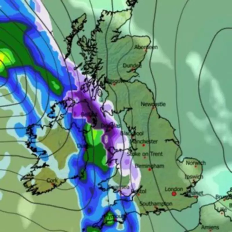
By mid-afternoon, a substantial band of precipitation is expected to stretch continuously from the southern English coastline all the way to the northernmost reaches of Scotland. During this period, several major urban centres could experience snowfall, including:

- Southampton
- Birmingham
- Manchester and Liverpool
- Edinburgh and Glasgow
The weather front is forecast to continue its easterly progression into the evening, potentially bringing snow to London around 9:00 PM, alongside areas of Yorkshire and the north-east of England. The system is then projected to move off into the North Sea, leaving a widespread snow cover in its wake.
Projected Snow Depth and National Coverage
Snow coverage maps for 6:00 AM on Saturday, February 15, depict an almost entirely purple-shaded United Kingdom, symbolising snow settled on the ground. The data suggests only isolated pockets may escape, including:
- Small sections of Northern Ireland
- Parts of the south-west peninsula
- Areas of East Anglia
- Some northern coastal fringes of Scotland
Accumulations could be substantial, particularly in elevated areas. The models indicate a potential for up to 19 centimetres (approximately seven inches) of snow on hills in northern Scotland. Meanwhile, northern England, the Midlands, and Wales could see accumulations of 5 to 6 centimetres (around two inches).
Broader Forecast Context from National Agencies
The broader meteorological outlook for the period supports the possibility of significant winter weather. The BBC Weather forecast for February 9 to 15 describes "changeable conditions" for the UK. It notes that while England and Wales should anticipate normal or above-average rainfall, the northern edges of any precipitation will be "susceptible to snow as they move into colder air, mostly on northern hills." The forecast adds uncertainty remains about the northward extent, but wintry showers are likely across northern regions, potentially reaching lower levels in Scotland.
The Met Office outlook for February 9 to 18 states that "cyclonic patterns are expected to dominate," with Atlantic frontal systems likely to approach and become slow-moving. This setup is expected to result in "showers or longer spells of rain spreading across the UK, these heavy at times," with the highest rainfall amounts probable in western areas. Crucially, the forecast confirms: "As these bands of rain spread northwards, snow is possible across northern England and Scotland, mainly over high ground." The Met Office also warns of the potential for strong winds, especially in coastal regions.
This confluence of forecasts from multiple models and agencies underscores the high probability of a widespread and impactful snow event affecting the vast majority of the United Kingdom in mid-February.


