
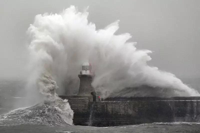
The United Kingdom is bracing for a weekend of severe weather disruption as Storm Ingrid sweeps across the nation, prompting the Met Office to issue multiple yellow weather warnings for heavy rain, snow, and powerful winds gusting up to 60 miles per hour.
Widespread Weather Warnings in Force
Three separate yellow weather warnings for rain have been activated, covering extensive areas from the south west of England and Wales to eastern Scotland and Northern Ireland. The persistent and heavy downpours are expected to cause significant localised flooding and create hazardous driving conditions throughout the affected regions.
Regional Impact and Forecast Details
In the south west of England and Wales, a heavy rain warning has been in effect since 2am on Friday and is set to remain until 10pm on Saturday. Storm Ingrid, which was named by the Portuguese Met Service (IPMA), is forecast to drift slowly northwards over the Celtic Sea during Saturday. This will bring bands of frequent heavy showers that may merge into prolonged spells of rain, with an expected additional rainfall of 20-40mm, and up to 50mm in some exposed locations.

Eastern parts of Scotland are facing a further 20-30mm of rain, with isolated spots potentially receiving up to 50mm, following three consecutive days of wet weather. This warning is active until 9am on Sunday. Notably, some areas have already recorded in excess of 100mm of rainfall. Above elevations of 400-500 metres, much of this precipitation will fall as snow, with rain confined to lower ground levels.
Northern Ireland is set to experience heavy rain from 8pm Saturday through to 9am Sunday. As part of the slow-moving low-pressure system, widespread rainfall of 10-20mm is anticipated, with some locations seeing as much as 25mm within a 12-hour period. This will be accompanied by strengthening easterly winds, gusting 30 to 35 mph inland and reaching 45 to 55 mph on certain coasts and over high ground, before easing after midnight.
Flooding Incidents and Travel Disruption
The adverse conditions have already led to serious travel disruptions and emergency incidents. Perth and Kinross Council reported that numerous roads in the region were closed due to flooding as of 6am on Friday. Key affected routes include the A94 between the A93 Meikleour crossroads and A923 Bendochy crossroads, as well as the Queen’s Bridge in Perth.
Emergency services were called into action on Thursday morning, with two people rescued from a minibus on the B977 near Kintore at approximately 8.30am. In a separate incident around the same time near Banchory, another individual was brought to safety from a stranded vehicle.
Across the south west of England and Wales, inland areas experienced gusts of 45 to 50mph, which peaked during Friday evening before gradually subsiding overnight into Saturday morning.
Flood Alerts and Official Statements
The Environment Agency has issued 30 flood warnings, indicating that flooding is expected, alongside 152 flood alerts where flooding is possible. In Scotland, the Scottish Environment Protection Agency has released 11 flood warnings and four alerts, while Natural Resources Wales has three alerts in place.
Met Office Chief Forecaster, Andy Page, commented: "Unsettled weather continues for many across the UK with persistent and heavy rain in parts of Scotland with snow over higher ground, and strong winds and heavy rain in southwestern England and southern Wales. Elsewhere, while it’ll be a breezy weekend, there will be brighter and drier spells with occasional showers passing through fairly quickly."
Areas Under Weather Warnings
The following regions are specifically affected by the Met Office warnings:

- Cornwall
- Devon
- Dorset
- Plymouth
- Somerset
- Torbay
- Blaenau Gwent
- County Antrim
- County Armagh
- County Down
- County Fermanagh
- County Londonderry
- County Tyrone
- Bridgend
- Caerphilly
- Cardiff
- Carmarthenshire
- Ceredigion
- Merthyr Tydfil
- Monmouthshire
- Neath Port Talbot
- Newport
- Pembrokeshire
- Powys
- Rhondda Cynon Taf
- Swansea
- Torfaen
- Vale of Glamorgan
- Angus
- Perth and Kinross
- Aberdeen
- Aberdeenshire
Residents in these areas are advised to stay updated with the latest forecasts, avoid unnecessary travel, and heed any local authority guidance regarding flood risks and road safety.


