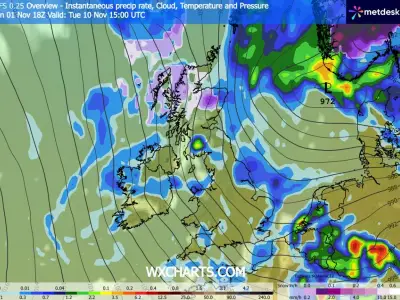
Snow is expected to fall across parts of Scotland from around 6pm on Wednesday, November 11, as a band of rain sweeps down the country, according to Met Office maps.
The national forecaster had previously warned that a "colder outbreak" could bring "wintry showers" to the northern UK, noting last week that the outcome of the looming colder weather system was "uncertain" after a period of calm high pressure.
Snowfall expected in Highlands and Grampian
The first snowfall is predicted to hit higher parts of Scotland, including Fort Augustus and Kingussie, with Orkney and Shetland also expected to see flurries on Wednesday evening. Through the night, those in Aberlour, Golspie, Inverness, and Aberdeen are forecast to see snow as the colder front continues.
According to weather maps, the Highlands and Grampian areas are expected to see wintry showers throughout Thursday, November 12, accompanied by scattered rainfall as a fresh wind brings a chill to the air, with frost likely to develop.
Southern Scotland braces for freezing temperatures
By 6pm on Wednesday, temperatures in Cumnock and Biggar are predicted to sit at -1C, with Kilmarnock, Moffat and Hawick at 0C. Temperatures are set to continue dropping overnight, with many parts of Dumfries and Galloway, Strathclyde and the Borders waking up to lows of -2C on Thursday morning.
The Met Office's forecast for Wednesday to Friday for Grampian and the Highlands reads: "Turning colder Wednesday and Thursday as a freshening northerly wind brings bright spells and a few showers, perhaps wintry for a time. Bright spells and showers Friday. Overnight frost possible."
Wintry conditions to persist into weekend
The last of the snow is expected to hit Ullapool and surrounding areas in the early hours of Friday morning (November 13), though rain is expected to persist through Friday and into the weekend.
The Met Office's long-range forecast from November 13 to November 22 states: "High pressure will initially dominate, leading to widely settled conditions and overnight frost. A few showers will be possible, particularly in northern and western Scotland, and perhaps along some North Sea coasts for a time."
It adds: "Later in the weekend, a transition to more unsettled conditions is expected as bands of rain, and associated areas of low pressure, arrive from the North Atlantic, bringing more widespread wet and windy weather."