
UK Braces for Massive 600-Mile Snow Storm
New weather maps from WXCharts indicate a colossal 600-mile snow storm is poised to strike the United Kingdom in just over a week, with significant snowfall expected to blanket major cities including London, Glasgow, Edinburgh, Newcastle, and Manchester. The storm is forecast to hit on Monday, February 16, bringing persistent snowfall throughout the day and potentially causing widespread disruption across the nation.
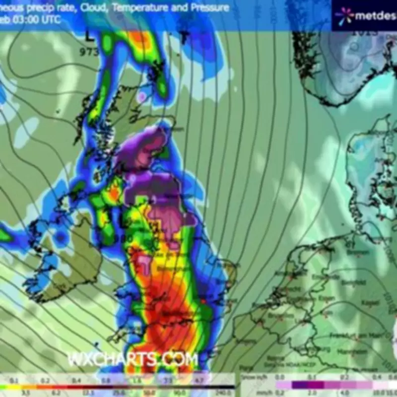
Detailed Snowfall Predictions Across Regions
The Scottish Highlands are anticipated to bear the brunt of the storm, with projections suggesting around 20 inches of snow could accumulate on the ground. Meanwhile, the Midlands may see up to 15 inches, and areas south of Glasgow could receive approximately seven inches. Currently, about 90% of Scotland appears to be covered in snow, with higher grounds and inland routes likely to experience challenging conditions that could impact travel and daily activities.
In contrast, southern parts of the UK will experience very different weather patterns. Most of England and Wales are expected to see rain rather than snow, particularly across the Midlands—including Stoke-on-Trent and Birmingham—as well as Greater London, Southampton, Swansea, Bristol, and the wider south-west region. By 6pm, much of this rain is forecast to clear, although unsettled conditions may persist in Wales, Gloucestershire, London, and along eastern coastal areas such as Ipswich, Norwich, and Kent. Heavy rain is also expected to remain in Blackpool during this period.

Expanding Snow Zone and Met Office Warnings
As the day progresses, the snow zone is predicted to expand southwards, with Newcastle likely to be the primary area outside Scotland to experience snowfall by the evening. Snow will continue across Glasgow, Dundee, Aberdeen, the Highlands, and the Cairngorms through the night, lasting until around 9pm on February 12. This comes as the Met Office has issued warnings of high pressure dominating the north or northeast next week, which will bring a mix of rain and snow to various parts of the country.
In its long-range forecast covering February 10-19, the Met Office states: "Predominantly cyclonic patterns are expected to dominate the UK. Further fronts are likely to approach the UK at times and then become slow-moving as they butt up against high pressure to the north or northeast of the UK. Thus some southern and western areas remain most prone to seeing the wettest conditions, which will maintain sensitivity to further flooding impacts."
The forecast adds: "Parts of northeast Britain may also be wetter than normal. Some snow is likely, especially in any colder airmasses that filter south or east into the UK and/or on the interface between mild and cold air. Strong winds are also possible at times. Temperatures will remain finely balanced during this period, with northeastern areas more likely to be colder than average, and southwestern areas perhaps seeing mild conditions at times."
Residents across the UK are advised to stay updated with the latest weather alerts and prepare for potential travel disruptions, school closures, and other impacts as this significant winter storm approaches. The combination of heavy snowfall in the north and rain in the south underscores the varied and unpredictable nature of British weather during this period.


